Casale Litta elevation
Casale Litta (Lombardy, Provincia di Varese), Italy elevation is 375 meters and Casale Litta elevation in feet is 1230 ft above sea level [src 1]. Casale Litta is a seat of a third-order administrative division (feature code) with elevation that is 53 meters (174 ft) bigger than average city elevation in Italy.
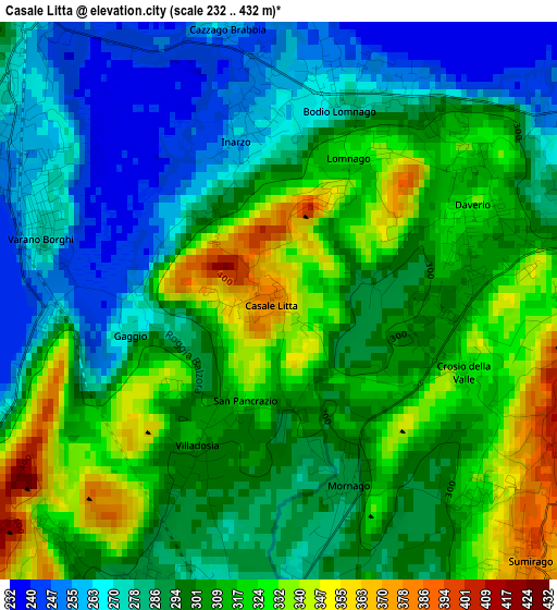
Below is the Elevation map of Casale Litta, which displays elevation range with different colors. Scale of the first map is from 232 to 432 m (761 to 1417 ft) with average elevation of 299.1 meters (=981 ft) [note 1]
These maps also provides idea of topography and contour of this city, they are displayed at different zoom levels. More info about maps, scale and edge coordinates you can find below images.
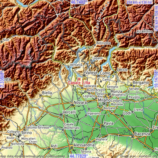
| \ | Map #1 | Topo.Map |
| Scale [m] | 232..432 m | × |
| Scale [ft] | 761..1417 ft | × |
| Average | 299.1 m = 981 ft | × |
| Width | 6.82 km = 4.2 mi | 218.1 km = 135.5 mi |
| Height | 6.82 km = 4.2 mi | 218.1 km = 135.5 mi |
| ↑Max Latitude | 45.798516° | 46.7402° |
| Latitude at center | 45.76787° | 45.76787° |
| ↓Min Latitude | 45.737207° | 44.77829° |
| ← Min Longitude | 8.697385° | 7.33508° |
| Longitude center | 8.74133° | 8.74133° |
| →Max Longitude | 8.785275° | 10.14758° |
Nearby cities:
Cities around Casale Litta sort by population:
• Azzate elevation 327 m
4.2 km,  74°
74°
• Daverio 330 m
2.7 km, 65°
• Varano Borghi 277 m
3 km,  283°
283°
• Ternate 259 m
3.9 km,  302°
302°
• Bodio 280 m
2.6 km,  17°
17°
• Bodio Lomnago 278 m
2.4 km, 17°
• Mornago 285 m
2.6 km,  164°
164°
• Cimbro 283 m
3.9 km,  204°
204°
• Inarzo 262 m
2 km,  347°
347°
• Galliate Lombardo 331 m
2.9 km,  50°
50°
• Cazzago Brabbia 247 m
3.2 km, 350°
• Crosio della Valle 325 m
2.4 km,  111°
111°
Multilingual:
 En español:
Casale Litta elevación 375 m.
 En France:
Casale Litta élévation 375 m.
 Auf Deutsch:
Casale Litta höhe über dem Meeresspiegel ist 375 m.

Sources and notes:
- [note 1] Map square and city borders are not equal. Map elevation data is calculated only from area inside that square.
- [src 1] Elevation data from geonames database provided with same terms of usage.
- [src 2] The elevation map of Casale Litta is generated using elevation data from NASA's 3 arcsec (90m) resolution SRTM data.
- [src 3] Base (background) map © OpenStreetMap contributors tiles are generated by Geofabrik and OpenTopoMap.
Copyright & License:
This Casale Litta Elevation Map is licensed under CC BY-SA. You may reuse any part from this page, if you give a proper credit by linking to this URL:
 More info on terms of use page.