Cunevo elevation
Cunevo (Trentino-Alto Adige, Provincia autonoma di Trento), Italy elevation is 579 meters and Cunevo elevation in feet is 1900 ft above sea level [src 1]. Cunevo is a seat of a third-order administrative division (feature code) with elevation that is 257 meters (843 ft) bigger than average city elevation in Italy.
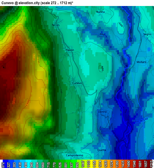
Below is the Elevation map of Cunevo, which displays elevation range with different colors. Scale of the first map is from 272 to 1712 m (892 to 5617 ft) with average elevation of 717.4 meters (=2354 ft) [note 1]
These maps also provides idea of topography and contour of this city, they are displayed at different zoom levels. More info about maps, scale and edge coordinates you can find below images.
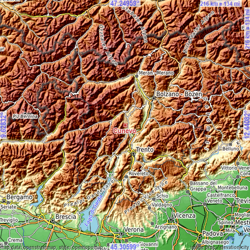
| \ | Map #1 | Topo.Map |
| Scale [m] | 272..1712 m | × |
| Scale [ft] | 892..5617 ft | × |
| Average | 717.4 m = 2354 ft | × |
| Width | 6.75 km = 4.2 mi | 216.1 km = 134.3 mi |
| Height | 6.75 km = 4.2 mi | 216.1 km = 134.3 mi |
| ↑Max Latitude | 46.31677° | 47.24959° |
| Latitude at center | 46.28641° | 46.28641° |
| ↓Min Latitude | 46.256033° | 45.30599° |
| ← Min Longitude | 10.990625° | 9.62832° |
| Longitude center | 11.03457° | 11.03457° |
| →Max Longitude | 11.078515° | 12.44082° |
Nearby cities:
Cities around Cunevo sort by population:
• Tuenno elevation 646 m
4.8 km,  349°
349°
• Tassullo 612 m
6.3 km,  7°
7°
• Taio 520 m
4.6 km,  32°
32°
• Denno 431 m
1.8 km,  140°
140°
• Tres 790 m
6.2 km,  50°
50°
• Sporminore 545 m
5.5 km,  184°
184°
• Vigo di Ton 464 m
4.7 km,  119°
119°
• Flavon 589 m
1.3 km,  344°
344°
• Nanno 555 m
3.3 km,  17°
17°
• Campodenno 546 m
3.2 km, 181°
• Vervò 906 m
7 km,  68°
68°
• Terres 583 m
2.8 km, 341°
Multilingual:
 En español:
Cunevo elevación 579 m.
 En France:
Cunevo élévation 579 m.


Sources and notes:
- [note 1] Map square and city borders are not equal. Map elevation data is calculated only from area inside that square.
- [src 1] Elevation data from geonames database provided with same terms of usage.
- [src 2] The elevation map of Cunevo is generated using elevation data from NASA's 3 arcsec (90m) resolution SRTM data.
- [src 3] Base (background) map © OpenStreetMap contributors tiles are generated by Geofabrik and OpenTopoMap.
Copyright & License:
This Cunevo Elevation Map is licensed under CC BY-SA. You may reuse any part from this page, if you give a proper credit by linking to this URL:
 More info on terms of use page.