Briosco elevation
Briosco (Lombardy, Provincia di Monza e della Brianza), Italy elevation is 273 meters and Briosco elevation in feet is 896 ft above sea level [src 1]. Briosco is a seat of a third-order administrative division (feature code) with elevation that is 49 meters (161 ft) smaller than average city elevation in Italy.
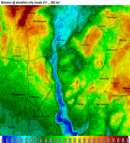
Below is the Elevation map of Briosco, which displays elevation range with different colors. Scale of the first map is from 211 to 362 m (692 to 1188 ft) with average elevation of 281.3 meters (=923 ft) [note 1]
These maps also provides idea of topography and contour of this city, they are displayed at different zoom levels. More info about maps, scale and edge coordinates you can find below images.
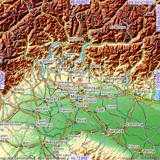
| \ | Map #1 | Topo.Map |
| Scale [m] | 211..362 m | × |
| Scale [ft] | 692..1188 ft | × |
| Average | 281.3 m = 923 ft | × |
| Width | 6.82 km = 4.2 mi | 218.4 km = 135.7 mi |
| Height | 6.82 km = 4.2 mi | 218.4 km = 135.7 mi |
| ↑Max Latitude | 45.740758° | 46.68343° |
| Latitude at center | 45.71008° | 45.71008° |
| ↓Min Latitude | 45.679385° | 44.71948° |
| ← Min Longitude | 9.196695° | 7.83439° |
| Longitude center | 9.24064° | 9.24064° |
| →Max Longitude | 9.284585° | 10.64689° |
Nearby cities:
Cities around Briosco sort by population:
• Giussano elevation 273 m
2.7 km,  245°
245°
• Carate Brianza 257 m
3.8 km,  183°
183°
• Verano Brianza 268 m
2.7 km,  207°
207°
• Inverigo 333 m
3.5 km,  330°
330°
• Carugo 275 m
3.4 km,  267°
267°
• Arosio 299 m
2.7 km,  292°
292°
• Veduggio Con Colzano 299 m
3.5 km,  40°
40°
• Renate 312 m
3.4 km,  62°
62°
• Capriano 316 m
1.8 km, 38°
• Villa Raverio 285 m
2.6 km,  140°
140°
• Zoccorino-Vergo 287 m
1.7 km, 144°
• Costa Lambro 257 m
2.8 km,  169°
169°
Multilingual:
 En español:
Briosco elevación 273 m.
 En France:
Briosco élévation 273 m.


Sources and notes:
- [note 1] Map square and city borders are not equal. Map elevation data is calculated only from area inside that square.
- [src 1] Elevation data from geonames database provided with same terms of usage.
- [src 2] The elevation map of Briosco is generated using elevation data from NASA's 3 arcsec (90m) resolution SRTM data.
- [src 3] Base (background) map © OpenStreetMap contributors tiles are generated by Geofabrik and OpenTopoMap.
Copyright & License:
This Briosco Elevation Map is licensed under CC BY-SA. You may reuse any part from this page, if you give a proper credit by linking to this URL:
 More info on terms of use page.