Curino elevation
Curino (Piedmont, Provincia di Biella), Italy elevation is 359 meters and Curino elevation in feet is 1178 ft above sea level [src 1]. Curino is a seat of a third-order administrative division (feature code) with elevation that is 37 meters (121 ft) bigger than average city elevation in Italy.
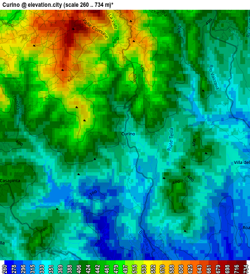
Below is the Elevation map of Curino, which displays elevation range with different colors. Scale of the first map is from 260 to 734 m (853 to 2408 ft) with average elevation of 407.8 meters (=1338 ft) [note 1]
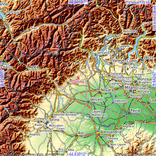
These maps also provides idea of topography and contour of this city, they are displayed at different zoom levels. More info about maps, scale and edge coordinates you can find below images.
| \ | Map #1 | Topo.Map |
| Scale [m] | 260..734 m | × |
| Scale [ft] | 853..2408 ft | × |
| Average | 407.8 m = 1338 ft | × |
| Width | 6.83 km = 4.2 mi | 218.7 km = 135.9 mi |
| Height | 6.83 km = 4.2 mi | 218.7 km = 135.9 mi |
| ↑Max Latitude | 45.657894° | 46.60197° |
| Latitude at center | 45.62717° | 45.62717° |
| ↓Min Latitude | 45.59643° | 44.63512° |
| ← Min Longitude | 8.192275° | 6.82997° |
| Longitude center | 8.23622° | 8.23622° |
| →Max Longitude | 8.280165° | 9.64247° |
Nearby cities:
Cities around Curino sort by population:
• Roasio elevation 287 m
4.5 km,  123°
123°
• Brusnengo 279 m
4.3 km,  163°
163°
• Masserano 340 m
3.7 km,  197°
197°
• Lessona 330 m
5.5 km,  216°
216°
• San Maurizio 307 m
4.7 km, 123°
• Soprana 468 m
3.2 km,  295°
295°
• Mezzana Mortigliengo 445 m
3.6 km,  268°
268°
• Sostegno 403 m
3.9 km,  42°
42°
• Fontanella-Ozino 461 m
5.3 km,  260°
260°
• Casapinta 431 m
3.4 km,  247°
247°
• Lanvario 490 m
3.2 km, 295°
• Villa del Bosco 334 m
3.4 km,  109°
109°
Multilingual:
 En español:
Curino elevación 359 m.
 En France:
Curino élévation 359 m.


Sources and notes:
- [note 1] Map square and city borders are not equal. Map elevation data is calculated only from area inside that square.
- [src 1] Elevation data from geonames database provided with same terms of usage.
- [src 2] The elevation map of Curino is generated using elevation data from NASA's 3 arcsec (90m) resolution SRTM data.
- [src 3] Base (background) map © OpenStreetMap contributors tiles are generated by Geofabrik and OpenTopoMap.
Copyright & License:
This Curino Elevation Map is licensed under CC BY-SA. You may reuse any part from this page, if you give a proper credit by linking to this URL:
 More info on terms of use page.