Conflenti elevation
Conflenti (Calabria, Provincia di Catanzaro), Italy elevation is 572 meters and Conflenti elevation in feet is 1877 ft above sea level [src 1]. Conflenti is a seat of a third-order administrative division (feature code) with elevation that is 250 meters (820 ft) bigger than average city elevation in Italy.
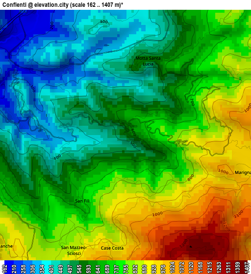
Below is the Elevation map of Conflenti, which displays elevation range with different colors. Scale of the first map is from 162 to 1407 m (531 to 4616 ft) with average elevation of 672.7 meters (=2207 ft) [note 1]
These maps also provides idea of topography and contour of this city, they are displayed at different zoom levels. More info about maps, scale and edge coordinates you can find below images.
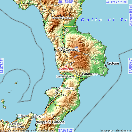
| \ | Map #1 | Topo.Map |
| Scale [m] | 162..1407 m | × |
| Scale [ft] | 531..4616 ft | × |
| Average | 672.7 m = 2207 ft | × |
| Width | 7.59 km = 4.7 mi | 242.8 km = 150.9 mi |
| Height | 7.59 km = 4.7 mi | 242.8 km = 150.9 mi |
| ↑Max Latitude | 39.105799° | 40.15498° |
| Latitude at center | 39.07169° | 39.07169° |
| ↓Min Latitude | 39.037564° | 37.97152° |
| ← Min Longitude | 16.240555° | 14.87825° |
| Longitude center | 16.2845° | 16.2845° |
| →Max Longitude | 16.328445° | 17.69075° |
Nearby cities:
Cities around Conflenti sort by population:
• Decollatura elevation 778 m
6.9 km,  113°
113°
• Soveria Mannelli 740 m
8 km,  85°
85°
• Grimaldi 627 m
8.8 km,  331°
331°
• San Mango d'Aquino 452 m
8.1 km,  261°
261°
• Platania 744 m
8 km,  156°
156°
• Motta Santa Lucia 527 m
2.3 km,  18°
18°
• Martirano Lombardo 529 m
4.5 km,  274°
274°
• Martirano 375 m
3.3 km,  288°
288°
• Calvisi 651 m
6.5 km, 16°
• Pedivigliano 597 m
4.6 km, 22°
• Carpanzano 590 m
8.7 km,  11°
11°
• Altilia 590 m
7.1 km,  337°
337°
Multilingual:
 En español:
Conflenti elevación 572 m.
 En France:
Conflenti élévation 572 m.
 Auf Deutsch:
Conflenti höhe über dem Meeresspiegel ist 572 m.

Sources and notes:
- [note 1] Map square and city borders are not equal. Map elevation data is calculated only from area inside that square.
- [src 1] Elevation data from geonames database provided with same terms of usage.
- [src 2] The elevation map of Conflenti is generated using elevation data from NASA's 3 arcsec (90m) resolution SRTM data.
- [src 3] Base (background) map © OpenStreetMap contributors tiles are generated by Geofabrik and OpenTopoMap.
Copyright & License:
This Conflenti Elevation Map is licensed under CC BY-SA. You may reuse any part from this page, if you give a proper credit by linking to this URL:
 More info on terms of use page.