Ultimo - Ulten elevation
Ultimo - Ulten (Trentino-Alto Adige, Bolzano), Italy elevation is 1118 meters and Ultimo - Ulten elevation in feet is 3668 ft above sea level [src 1]. Ultimo - Ulten is a seat of a third-order administrative division (feature code) with elevation that is 796 meters (2612 ft) bigger than average city elevation in Italy.
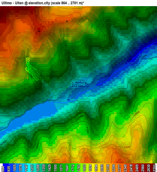
Below is the Elevation map of Ultimo - Ulten, which displays elevation range with different colors. Scale of the first map is from 864 to 2701 m (2835 to 8862 ft) with average elevation of 1652.4 meters (=5421 ft) [note 1]
These maps also provides idea of topography and contour of this city, they are displayed at different zoom levels. More info about maps, scale and edge coordinates you can find below images.
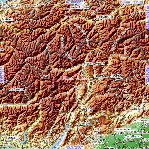
| \ | Map #1 | Topo.Map |
| Scale [m] | 864..2701 m | × |
| Scale [ft] | 2835..8862 ft | × |
| Average | 1652.4 m = 5421 ft | × |
| Width | 6.72 km = 4.2 mi | 215.1 km = 133.7 mi |
| Height | 6.72 km = 4.2 mi | 215.1 km = 133.7 mi |
| ↑Max Latitude | 46.578535° | 47.50685° |
| Latitude at center | 46.54832° | 46.54832° |
| ↓Min Latitude | 46.518089° | 45.57256° |
| ← Min Longitude | 10.960225° | 9.59792° |
| Longitude center | 11.00417° | 11.00417° |
| →Max Longitude | 11.048115° | 12.41042° |
Nearby cities:
Cities around Ultimo - Ulten sort by population:
• Naturno elevation 528 m
11.1 km,  358°
358°
• Castelbello-Ciardes - Kastelbell-Tschars 570 m
11.6 km,  320°
320°
• Castelbello 568 m
11.6 km, 320°
• Santa Valburga 1253 m
0.4 km,  300°
300°
• Rumo 955 m
11.9 km,  174°
174°
• Tesimo 636 m
12.8 km,  81°
81°
• Plaus 514 m
12.3 km,  13°
13°
• San Pancrazio 748 m
7.5 km,  56°
56°
• Proves - Proveis 1412 m
8.1 km, 170°
• San Felice 1292 m
11.4 km,  121°
121°
• Lauregno 1152 m
11.3 km,  157°
157°
• Senale 1354 m
9.1 km, 117°
Multilingual:
 En español:
Ultimo - Ulten elevación 1118 m.
 En France:
Ultimo - Ulten élévation 1118 m.


Sources and notes:
- [note 1] Map square and city borders are not equal. Map elevation data is calculated only from area inside that square.
- [src 1] Elevation data from geonames database provided with same terms of usage.
- [src 2] The elevation map of Ultimo - Ulten is generated using elevation data from NASA's 3 arcsec (90m) resolution SRTM data.
- [src 3] Base (background) map © OpenStreetMap contributors tiles are generated by Geofabrik and OpenTopoMap.
Copyright & License:
This Ultimo - Ulten Elevation Map is licensed under CC BY-SA. You may reuse any part from this page, if you give a proper credit by linking to this URL:
 More info on terms of use page.