Saint Marcel elevation
Saint Marcel (Aosta Valley, Valle d'Aosta), Italy elevation is 601 meters and Saint Marcel elevation in feet is 1972 ft above sea level [src 1]. Saint Marcel is a seat of a third-order administrative division (feature code) with elevation that is 279 meters (915 ft) bigger than average city elevation in Italy.
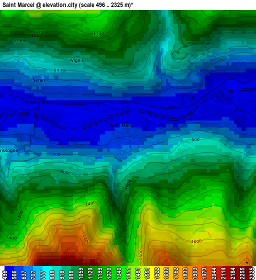
Below is the Elevation map of Saint Marcel, which displays elevation range with different colors. Scale of the first map is from 496 to 2325 m (1627 to 7628 ft) with average elevation of 1027.1 meters (=3370 ft) [note 1]
These maps also provides idea of topography and contour of this city, they are displayed at different zoom levels. More info about maps, scale and edge coordinates you can find below images.
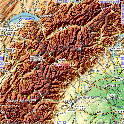
| \ | Map #1 | Topo.Map |
| Scale [m] | 496..2325 m | × |
| Scale [ft] | 1627..7628 ft | × |
| Average | 1027.1 m = 3370 ft | × |
| Width | 6.82 km = 4.2 mi | 218.3 km = 135.6 mi |
| Height | 6.82 km = 4.2 mi | 218.3 km = 135.6 mi |
| ↑Max Latitude | 45.762126° | 46.70443° |
| Latitude at center | 45.73146° | 45.73146° |
| ↓Min Latitude | 45.700777° | 44.74124° |
| ← Min Longitude | 7.404255° | 6.04195° |
| Longitude center | 7.4482° | 7.4482° |
| →Max Longitude | 7.492145° | 8.85445° |
Nearby cities:
Cities around Saint Marcel sort by population:
• Quart elevation 541 m
2.8 km,  292°
292°
• Saint-Christophe 774 m
8.2 km, 287°
• Chef-Lieu 692 m
7.6 km, 286°
• Nus 541 m
1.7 km,  55°
55°
• Villair-Amerique 618 m
4.9 km, 292°
• Fénis 544 m
3.7 km,  84°
84°
• Pollein 589 m
7.5 km,  266°
266°
• Villefranche 545 m
2.7 km, 292°
• Chambave 490 m
8 km, 79°
• Verrayes 1019 m
7.6 km, 62°
• Grand Brissogne 891 m
4.4 km,  261°
261°
• Petit Fenis 934 m
2.5 km,  29°
29°
Multilingual:
 En español:
Saint Marcel elevación 601 m.
 En France:
Saint Marcel élévation 601 m.
 Auf Deutsch:
Saint Marcel höhe über dem Meeresspiegel ist 601 m.

Sources and notes:
- [note 1] Map square and city borders are not equal. Map elevation data is calculated only from area inside that square.
- [src 1] Elevation data from geonames database provided with same terms of usage.
- [src 2] The elevation map of Saint Marcel is generated using elevation data from NASA's 3 arcsec (90m) resolution SRTM data.
- [src 3] Base (background) map © OpenStreetMap contributors tiles are generated by Geofabrik and OpenTopoMap.
Copyright & License:
This Saint Marcel Elevation Map is licensed under CC BY-SA. You may reuse any part from this page, if you give a proper credit by linking to this URL:
 More info on terms of use page.