Lisignago elevation
Lisignago (Trentino-Alto Adige, Provincia autonoma di Trento), Italy elevation is 590 meters and Lisignago elevation in feet is 1936 ft above sea level [src 1]. Lisignago is a seat of a third-order administrative division (feature code) with elevation that is 268 meters (879 ft) bigger than average city elevation in Italy.
Below is the Elevation map of Lisignago, which displays elevation range with different colors. Scale of the first map is from 289 to 1247 m (948 to 4091 ft) with average elevation of 725.4 meters (=2380 ft) [note 1]
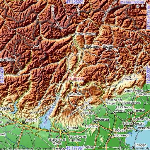
These maps also provides idea of topography and contour of this city, they are displayed at different zoom levels. More info about maps, scale and edge coordinates you can find below images.
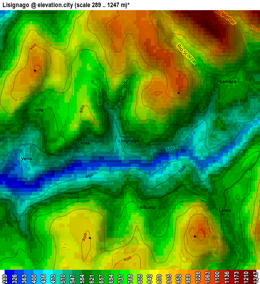
| \ | Map #1 | Topo.Map |
| Scale [m] | 289..1247 m | × |
| Scale [ft] | 948..4091 ft | × |
| Average | 725.4 m = 2380 ft | × |
| Width | 6.77 km = 4.2 mi | 216.6 km = 134.6 mi |
| Height | 6.77 km = 4.2 mi | 216.6 km = 134.6 mi |
| ↑Max Latitude | 46.19104° | 47.12602° |
| Latitude at center | 46.16061° | 46.16061° |
| ↓Min Latitude | 46.130163° | 45.17796° |
| ← Min Longitude | 11.143735° | 9.78143° |
| Longitude center | 11.18768° | 11.18768° |
| →Max Longitude | 11.231625° | 12.59393° |
Nearby cities:
Cities around Lisignago sort by population:
• Baselga di Pinè elevation 961 m
5.5 km,  124°
124°
• San Michele All'Adige 202 m
5.4 km,  307°
307°
• Giovo 497 m
2.7 km,  258°
258°
• Cembra 661 m
3.1 km,  58°
58°
• Albiano 646 m
1.9 km,  163°
163°
• Fornace 719 m
5 km, 162°
• Miola di Pinè 998 m
6 km,  128°
128°
• Verla 515 m
2.7 km, 263°
• Faver 684 m
4.5 km, 58°
• Lona-Lases 635 m
3.1 km, 126°
• Lases 638 m
3 km, 124°
• Faedo 600 m
4.1 km,  330°
330°
Multilingual:
 En español:
Lisignago elevación 590 m.
 En France:
Lisignago élévation 590 m.
 Auf Deutsch:
Lisignago höhe über dem Meeresspiegel ist 590 m.

Sources and notes:
- [note 1] Map square and city borders are not equal. Map elevation data is calculated only from area inside that square.
- [src 1] Elevation data from geonames database provided with same terms of usage.
- [src 2] The elevation map of Lisignago is generated using elevation data from NASA's 3 arcsec (90m) resolution SRTM data.
- [src 3] Base (background) map © OpenStreetMap contributors tiles are generated by Geofabrik and OpenTopoMap.
Copyright & License:
This Lisignago Elevation Map is licensed under CC BY-SA. You may reuse any part from this page, if you give a proper credit by linking to this URL:
 More info on terms of use page.