Torre de' Negri elevation
Torre de' Negri (Lombardy, Provincia di Pavia), Italy elevation is 71 meters and Torre de' Negri elevation in feet is 233 ft above sea level [src 1]. Torre de' Negri is a seat of a third-order administrative division (feature code) with elevation that is 251 meters (823 ft) smaller than average city elevation in Italy.
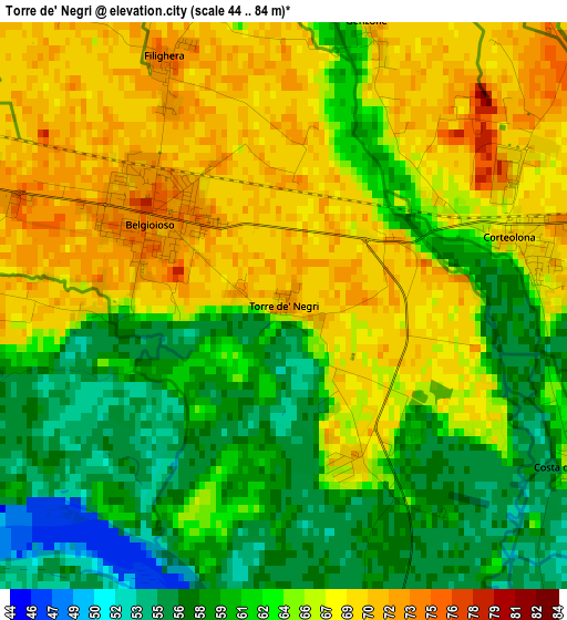
Below is the Elevation map of Torre de' Negri, which displays elevation range with different colors. Scale of the first map is from 44 to 84 m (144 to 276 ft) with average elevation of 64.1 meters (=210 ft) [note 1]
These maps also provides idea of topography and contour of this city, they are displayed at different zoom levels. More info about maps, scale and edge coordinates you can find below images.
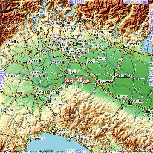
| \ | Map #1 | Topo.Map |
| Scale [m] | 44..84 m | × |
| Scale [ft] | 144..276 ft | × |
| Average | 64.1 m = 210 ft | × |
| Width | 6.89 km = 4.3 mi | 220.5 km = 137 mi |
| Height | 6.89 km = 4.3 mi | 220.5 km = 137 mi |
| ↑Max Latitude | 45.180644° | 46.1328° |
| Latitude at center | 45.14966° | 45.14966° |
| ↓Min Latitude | 45.118659° | 44.14926° |
| ← Min Longitude | 9.290615° | 7.92831° |
| Longitude center | 9.33456° | 9.33456° |
| →Max Longitude | 9.378505° | 10.74081° |
Nearby cities:
Cities around Torre de' Negri sort by population:
• Belgioioso elevation 73 m
2 km,  303°
303°
• Corteolona 70 m
3.1 km,  72°
72°
• Linarolo 73 m
5.3 km,  285°
285°
• Santa Cristina 71 m
5.2 km,  80°
80°
• Copiano 73 m
5.4 km,  351°
351°
• Portalbera 62 m
5.9 km,  192°
192°
• Filighera 73 m
3.2 km,  333°
333°
• San Zenone al Po 60 m
5 km,  154°
154°
• San Cipriano Po 60 m
6.2 km,  223°
223°
• Genzone 71 m
3.5 km,  17°
17°
• Spessa 62 m
4.2 km,  164°
164°
• Costa de' Nobili 64 m
4 km,  119°
119°
Multilingual:
 En español:
Torre de' Negri elevación 71 m.
 En France:
Torre de' Negri élévation 71 m.
 Auf Deutsch:
Torre de' Negri höhe über dem Meeresspiegel ist 71 m.

Sources and notes:
- [note 1] Map square and city borders are not equal. Map elevation data is calculated only from area inside that square.
- [src 1] Elevation data from geonames database provided with same terms of usage.
- [src 2] The elevation map of Torre de' Negri is generated using elevation data from NASA's 3 arcsec (90m) resolution SRTM data.
- [src 3] Base (background) map © OpenStreetMap contributors tiles are generated by Geofabrik and OpenTopoMap.
Copyright & License:
This Torre de' Negri Elevation Map is licensed under CC BY-SA. You may reuse any part from this page, if you give a proper credit by linking to this URL:
 More info on terms of use page.