Rovescala elevation
Rovescala (Lombardy, Provincia di Pavia), Italy elevation is 270 meters and Rovescala elevation in feet is 886 ft above sea level [src 1]. Rovescala is a seat of a third-order administrative division (feature code) with elevation that is 52 meters (171 ft) smaller than average city elevation in Italy.
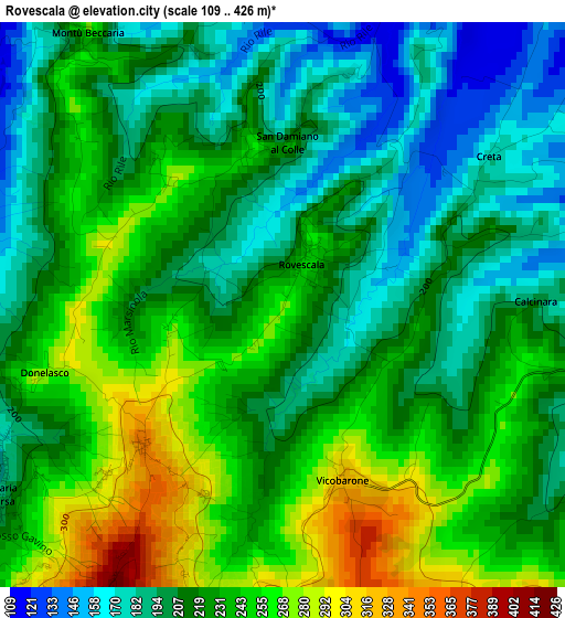
Below is the Elevation map of Rovescala, which displays elevation range with different colors. Scale of the first map is from 109 to 426 m (358 to 1398 ft) with average elevation of 222 meters (=728 ft) [note 1]
These maps also provides idea of topography and contour of this city, they are displayed at different zoom levels. More info about maps, scale and edge coordinates you can find below images.
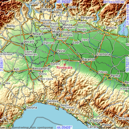
| \ | Map #1 | Topo.Map |
| Scale [m] | 109..426 m | × |
| Scale [ft] | 358..1398 ft | × |
| Average | 222 m = 728 ft | × |
| Width | 6.91 km = 4.3 mi | 221.1 km = 137.4 mi |
| Height | 6.91 km = 4.3 mi | 221.1 km = 137.4 mi |
| ↑Max Latitude | 45.038022° | 45.99258° |
| Latitude at center | 45.00696° | 45.00696° |
| ↓Min Latitude | 44.975881° | 44.00408° |
| ← Min Longitude | 9.301915° | 7.93961° |
| Longitude center | 9.34586° | 9.34586° |
| →Max Longitude | 9.389805° | 10.75211° |
Nearby cities:
Cities around Rovescala sort by population:
• Santa Maria della Versa elevation 198 m
4.2 km,  239°
239°
• Montù Beccaria 213 m
4.2 km,  321°
321°
• Ziano Piacentino 211 m
3.9 km,  101°
101°
• San Damiano al Colle 207 m
2.3 km,  5°
5°
• Montecalvo Versiggia 357 m
6.1 km,  230°
230°
• Canneto 229 m
7.1 km,  313°
313°
• Castana 290 m
6.2 km,  290°
290°
• Zenevredo 187 m
5.4 km,  343°
343°
• Volpara 343 m
7 km,  212°
212°
• Bosnasco 120 m
6.4 km, 7°
• Golferenzo 432 m
6 km, 211°
• Montescano 198 m
5.6 km,  299°
299°
Multilingual:
 En español:
Rovescala elevación 270 m.
 En France:
Rovescala élévation 270 m.
 Auf Deutsch:
Rovescala höhe über dem Meeresspiegel ist 270 m.

Sources and notes:
- [note 1] Map square and city borders are not equal. Map elevation data is calculated only from area inside that square.
- [src 1] Elevation data from geonames database provided with same terms of usage.
- [src 2] The elevation map of Rovescala is generated using elevation data from NASA's 3 arcsec (90m) resolution SRTM data.
- [src 3] Base (background) map © OpenStreetMap contributors tiles are generated by Geofabrik and OpenTopoMap.
Copyright & License:
This Rovescala Elevation Map is licensed under CC BY-SA. You may reuse any part from this page, if you give a proper credit by linking to this URL:
 More info on terms of use page.