Bleggio Superiore elevation
Bleggio Superiore (Trentino-Alto Adige, Provincia autonoma di Trento), Italy elevation is 634 meters and Bleggio Superiore elevation in feet is 2080 ft above sea level [src 1]. Bleggio Superiore is a seat of a third-order administrative division (feature code) with elevation that is 312 meters (1024 ft) bigger than average city elevation in Italy.
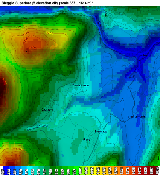
Below is the Elevation map of Bleggio Superiore, which displays elevation range with different colors. Scale of the first map is from 387 to 1614 m (1270 to 5295 ft) with average elevation of 729.4 meters (=2393 ft) [note 1]
These maps also provides idea of topography and contour of this city, they are displayed at different zoom levels. More info about maps, scale and edge coordinates you can find below images.
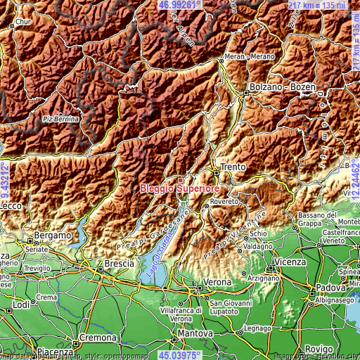
| \ | Map #1 | Topo.Map |
| Scale [m] | 387..1614 m | × |
| Scale [ft] | 1270..5295 ft | × |
| Average | 729.4 m = 2393 ft | × |
| Width | 6.79 km = 4.2 mi | 217.1 km = 134.9 mi |
| Height | 6.79 km = 4.2 mi | 217.1 km = 134.9 mi |
| ↑Max Latitude | 46.055305° | 46.99261° |
| Latitude at center | 46.0248° | 46.0248° |
| ↓Min Latitude | 45.994278° | 45.03975° |
| ← Min Longitude | 10.794425° | 9.43212° |
| Longitude center | 10.83837° | 10.83837° |
| →Max Longitude | 10.882315° | 12.24462° |
Nearby cities:
Cities around Bleggio Superiore sort by population:
• Tione di Trento elevation 568 m
8.7 km,  277°
277°
• San Lorenzo in Banale 729 m
7.9 km,  43°
43°
• Pietramurata 249 m
8.1 km,  93°
93°
• Ponte Arche 404 m
2.9 km,  66°
66°
• Fiavè 669 m
2.3 km,  172°
172°
• Stenico 647 m
3.2 km,  24°
24°
• Ragoli 569 m
5.7 km,  305°
305°
• Preore 529 m
6.5 km,  291°
291°
• Bolbeno 574 m
7.8 km, 276°
• Zuclo 596 m
6.8 km, 278°
• Dorsino 636 m
7 km, 40°
• Montagne 943 m
7.7 km,  299°
299°
Multilingual:
 En español:
Bleggio Superiore elevación 634 m.
 En France:
Bleggio Superiore élévation 634 m.
 Auf Deutsch:
Bleggio Superiore höhe über dem Meeresspiegel ist 634 m.

Sources and notes:
- [note 1] Map square and city borders are not equal. Map elevation data is calculated only from area inside that square.
- [src 1] Elevation data from geonames database provided with same terms of usage.
- [src 2] The elevation map of Bleggio Superiore is generated using elevation data from NASA's 3 arcsec (90m) resolution SRTM data.
- [src 3] Base (background) map © OpenStreetMap contributors tiles are generated by Geofabrik and OpenTopoMap.
Copyright & License:
This Bleggio Superiore Elevation Map is licensed under CC BY-SA. You may reuse any part from this page, if you give a proper credit by linking to this URL:
 More info on terms of use page.