Losine elevation
Losine (Lombardy, Provincia di Brescia), Italy elevation is 391 meters and Losine elevation in feet is 1283 ft above sea level [src 1]. Losine is a seat of a third-order administrative division (feature code) with elevation that is 69 meters (226 ft) bigger than average city elevation in Italy.
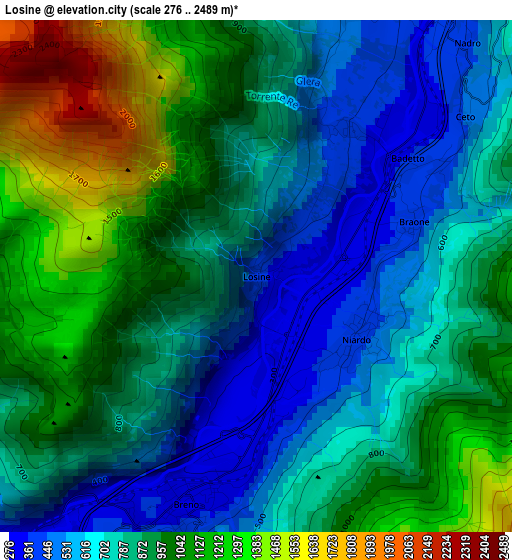
Below is the Elevation map of Losine, which displays elevation range with different colors. Scale of the first map is from 276 to 2489 m (906 to 8166 ft) with average elevation of 848 meters (=2782 ft) [note 1]
These maps also provides idea of topography and contour of this city, they are displayed at different zoom levels. More info about maps, scale and edge coordinates you can find below images.
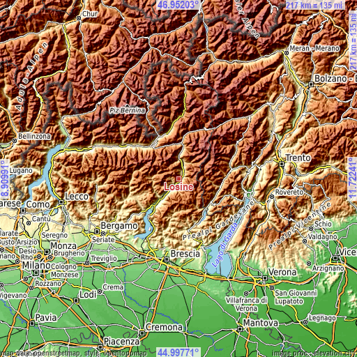
| \ | Map #1 | Topo.Map |
| Scale [m] | 276..2489 m | × |
| Scale [ft] | 906..8166 ft | × |
| Average | 848 m = 2782 ft | × |
| Width | 6.79 km = 4.2 mi | 217.3 km = 135 mi |
| Height | 6.79 km = 4.2 mi | 217.3 km = 135 mi |
| ↑Max Latitude | 46.014018° | 46.95203° |
| Latitude at center | 45.98349° | 45.98349° |
| ↓Min Latitude | 45.952945° | 44.99771° |
| ← Min Longitude | 10.272215° | 8.90991° |
| Longitude center | 10.31616° | 10.31616° |
| →Max Longitude | 10.360105° | 11.72241° |
Nearby cities:
Cities around Losine sort by population:
• Breno elevation 312 m
2.8 km,  195°
195°
• Bienno 436 m
5.7 km, 198°
• Cividate Camuno 264 m
6.1 km,  219°
219°
• Capo di Ponte 368 m
5.6 km,  21°
21°
• Malegno 302 m
4.9 km, 221°
• Niardo 425 m
1.6 km,  122°
122°
• Ono San Pietro 499 m
3.8 km,  14°
14°
• Cerveno 420 m
2.2 km, 24°
• Cimbergo 876 m
5.9 km,  40°
40°
• Braone 382 m
2.1 km,  69°
69°
• Lozio 1003 m
4.3 km,  273°
273°
• Ceto 458 m
3.5 km,  52°
52°
Multilingual:
 En español:
Losine elevación 391 m.
 En France:
Losine élévation 391 m.


Sources and notes:
- [note 1] Map square and city borders are not equal. Map elevation data is calculated only from area inside that square.
- [src 1] Elevation data from geonames database provided with same terms of usage.
- [src 2] The elevation map of Losine is generated using elevation data from NASA's 3 arcsec (90m) resolution SRTM data.
- [src 3] Base (background) map © OpenStreetMap contributors tiles are generated by Geofabrik and OpenTopoMap.
Copyright & License:
This Losine Elevation Map is licensed under CC BY-SA. You may reuse any part from this page, if you give a proper credit by linking to this URL:
 More info on terms of use page.