Viadanica elevation
Viadanica (Lombardy, Provincia di Bergamo), Italy elevation is 317 meters and Viadanica elevation in feet is 1040 ft above sea level [src 1]. Viadanica is a seat of a third-order administrative division (feature code) with elevation that is 5 meters (16 ft) smaller than average city elevation in Italy.
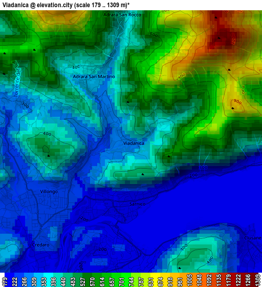
Below is the Elevation map of Viadanica, which displays elevation range with different colors. Scale of the first map is from 179 to 1309 m (587 to 4295 ft) with average elevation of 430.4 meters (=1412 ft) [note 1]
These maps also provides idea of topography and contour of this city, they are displayed at different zoom levels. More info about maps, scale and edge coordinates you can find below images.
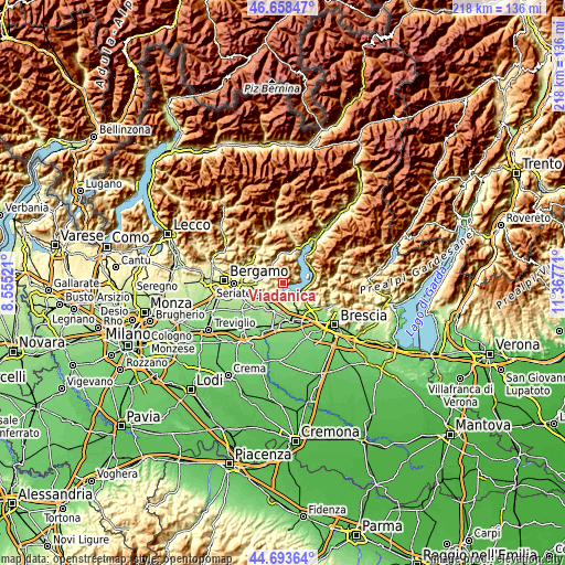
| \ | Map #1 | Topo.Map |
| Scale [m] | 179..1309 m | × |
| Scale [ft] | 587..4295 ft | × |
| Average | 430.4 m = 1412 ft | × |
| Width | 6.83 km = 4.2 mi | 218.5 km = 135.8 mi |
| Height | 6.83 km = 4.2 mi | 218.5 km = 135.8 mi |
| ↑Max Latitude | 45.715372° | 46.65847° |
| Latitude at center | 45.68468° | 45.68468° |
| ↓Min Latitude | 45.653971° | 44.69364° |
| ← Min Longitude | 9.917515° | 8.55521° |
| Longitude center | 9.96146° | 9.96146° |
| →Max Longitude | 10.005405° | 11.36771° |
Nearby cities:
Cities around Viadanica sort by population:
• Villongo elevation 231 m
2.9 km,  234°
234°
• Sarnico 201 m
1.5 km,  179°
179°
• Colombaro-Timoline 219 m
5.2 km,  150°
150°
• Paratico 224 m
2.9 km,  185°
185°
• Chiesa 347 m
3.8 km,  279°
279°
• Foresto Sparso 262 m
3.3 km, 282°
• Credaro 232 m
3.6 km,  221°
221°
• Clusane 192 m
3.9 km,  129°
129°
• Predore 194 m
4 km,  96°
96°
• Adrara San Martino 402 m
2.2 km,  333°
333°
• Berzo San Fermo 341 m
5.9 km,  310°
310°
• Adrara San Rocco 432 m
3.5 km,  356°
356°
Multilingual:
 En español:
Viadanica elevación 317 m.
 En France:
Viadanica élévation 317 m.
 Auf Deutsch:
Viadanica höhe über dem Meeresspiegel ist 317 m.

Sources and notes:
- [note 1] Map square and city borders are not equal. Map elevation data is calculated only from area inside that square.
- [src 1] Elevation data from geonames database provided with same terms of usage.
- [src 2] The elevation map of Viadanica is generated using elevation data from NASA's 3 arcsec (90m) resolution SRTM data.
- [src 3] Base (background) map © OpenStreetMap contributors tiles are generated by Geofabrik and OpenTopoMap.
Copyright & License:
This Viadanica Elevation Map is licensed under CC BY-SA. You may reuse any part from this page, if you give a proper credit by linking to this URL:
 More info on terms of use page.