Piazzolo elevation
Piazzolo (Lombardy, Provincia di Bergamo), Italy elevation is 711 meters and Piazzolo elevation in feet is 2333 ft above sea level [src 1]. Piazzolo is a seat of a third-order administrative division (feature code) with elevation that is 389 meters (1276 ft) bigger than average city elevation in Italy.
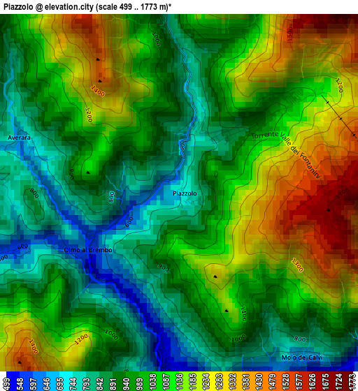
Below is the Elevation map of Piazzolo, which displays elevation range with different colors. Scale of the first map is from 499 to 1773 m (1637 to 5817 ft) with average elevation of 1028 meters (=3373 ft) [note 1]
These maps also provides idea of topography and contour of this city, they are displayed at different zoom levels. More info about maps, scale and edge coordinates you can find below images.
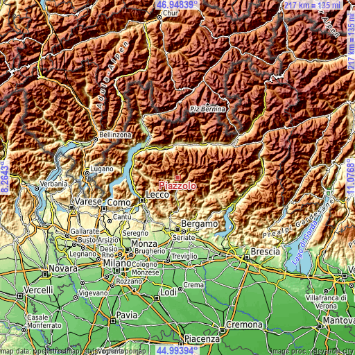
| \ | Map #1 | Topo.Map |
| Scale [m] | 499..1773 m | × |
| Scale [ft] | 1637..5817 ft | × |
| Average | 1028 m = 3373 ft | × |
| Width | 6.79 km = 4.2 mi | 217.3 km = 135 mi |
| Height | 6.79 km = 4.2 mi | 217.3 km = 135 mi |
| ↑Max Latitude | 46.01032° | 46.94839° |
| Latitude at center | 45.97979° | 45.97979° |
| ↓Min Latitude | 45.949243° | 44.99394° |
| ← Min Longitude | 9.626605° | 8.2643° |
| Longitude center | 9.67055° | 9.67055° |
| →Max Longitude | 9.714495° | 11.0768° |
Nearby cities:
Cities around Piazzolo sort by population:
• Piazza Brembana elevation 515 m
3.6 km,  176°
176°
• Santa Brigida 785 m
3.9 km,  278°
278°
• Colla-Muggiasca 806 m
3.7 km, 276°
• Lenna 479 m
4.2 km,  171°
171°
• Piazzatorre 929 m
2 km,  45°
45°
• Olmo al Brembo 573 m
1.9 km,  235°
235°
• Cusio 1043 m
5.5 km, 283°
• Moio de' Calvi 661 m
3.9 km,  143°
143°
• Valnegra 578 m
3.7 km,  156°
156°
• Mezzoldo 855 m
3.7 km,  353°
353°
• Averara 651 m
3.2 km,  287°
287°
• Cassiglio 607 m
4.7 km,  252°
252°
Multilingual:
 En español:
Piazzolo elevación 711 m.
 En France:
Piazzolo élévation 711 m.
 Auf Deutsch:
Piazzolo höhe über dem Meeresspiegel ist 711 m.

Sources and notes:
- [note 1] Map square and city borders are not equal. Map elevation data is calculated only from area inside that square.
- [src 1] Elevation data from geonames database provided with same terms of usage.
- [src 2] The elevation map of Piazzolo is generated using elevation data from NASA's 3 arcsec (90m) resolution SRTM data.
- [src 3] Base (background) map © OpenStreetMap contributors tiles are generated by Geofabrik and OpenTopoMap.
Copyright & License:
This Piazzolo Elevation Map is licensed under CC BY-SA. You may reuse any part from this page, if you give a proper credit by linking to this URL:
 More info on terms of use page.