Basiano elevation
Basiano (Lombardy, Città metropolitana di Milano), Italy elevation is 170 meters and Basiano elevation in feet is 558 ft above sea level [src 1]. Basiano is a seat of a third-order administrative division (feature code) with elevation that is 152 meters (499 ft) smaller than average city elevation in Italy.
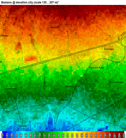
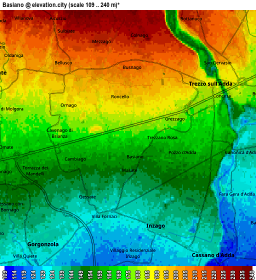
Below is the Elevation map of Basiano, which displays elevation range with different colors. Scale of the first map is from 130 to 207 m (427 to 679 ft) with average elevation of 170 meters (=558 ft) [note 1]
These maps also provides idea of topography and contour of this city, they are displayed at different zoom levels. More info about maps, scale and edge coordinates you can find below images.
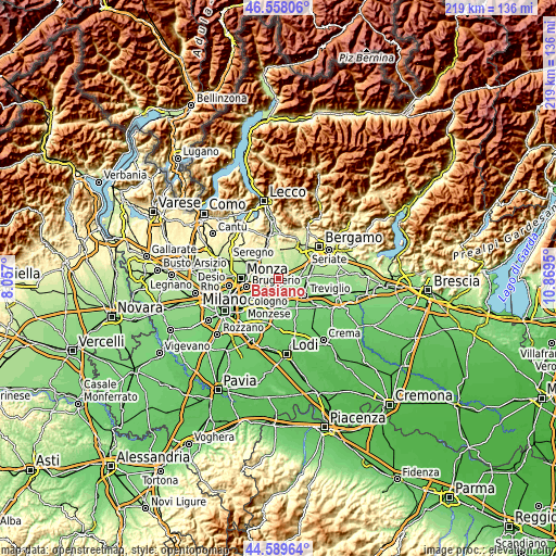
| \ | Map #1 | Map #2 | Topo.Map |
| Scale [m] | 130..207 m | 109..240 m | × |
| Scale [ft] | 427..679 ft | 358..787 ft | × |
| Average | 170 m = 558 ft | 168.6 m = 553 ft | × |
| Width | 6.84 km = 4.3 mi | 13.68 km = 8.5 mi | 218.9 km = 136 mi |
| Height | 6.84 km = 4.3 mi | 13.68 km = 8.5 mi | 218.9 km = 136 mi |
| ↑Max Latitude | 45.613228° | 45.643959° | 46.55806° |
| Latitude at center | 45.58248° | 45.58248° | 45.58248° |
| ↓Min Latitude | 45.551715° | 45.520933° | 44.58964° |
| ← Min Longitude | 9.419305° | 9.375359° | 8.057° |
| Longitude center | 9.46325° | 9.46325° | 9.46325° |
| →Max Longitude | 9.507195° | 9.551141° | 10.8695° |
Nearby cities:
Cities around Basiano sort by population:
• Trezzo sull'Adda elevation 181 m
4.7 km,  57°
57°
• Gessate 136 m
4.3 km,  207°
207°
• Cavenago di Brianza 175 m
3.9 km,  270°
270°
• Busnago 211 m
3.8 km,  0°
0°
• Cambiago 168 m
2.2 km,  263°
263°
• Trezzano Rosa 170 m
1.7 km,  90°
90°
• Ornago 191 m
3.8 km,  300°
300°
• Roncello 195 m
2.3 km,  343°
343°
• Bellinzago Lombardo 131 m
4.7 km,  196°
196°
• Masate 149 m
1.7 km,  177°
177°
• Pozzo d'Adda 160 m
3.3 km,  109°
109°
• Grezzago 179 m
2.8 km,  70°
70°
Multilingual:
 En español:
Basiano elevación 170 m.
 En France:
Basiano élévation 170 m.


Sources and notes:
- [note 1] Map square and city borders are not equal. Map elevation data is calculated only from area inside that square.
- [src 1] Elevation data from geonames database provided with same terms of usage.
- [src 2] The elevation map of Basiano is generated using elevation data from NASA's 3 arcsec (90m) resolution SRTM data.
- [src 3] Base (background) map © OpenStreetMap contributors tiles are generated by Geofabrik and OpenTopoMap.
Copyright & License:
This Basiano Elevation Map is licensed under CC BY-SA. You may reuse any part from this page, if you give a proper credit by linking to this URL:
 More info on terms of use page.