Moconesi elevation
Moconesi (Liguria, Provincia di Genova), Italy elevation is 139 meters and Moconesi elevation in feet is 456 ft above sea level [src 1]. Moconesi is a seat of a third-order administrative division (feature code) with elevation that is 183 meters (600 ft) smaller than average city elevation in Italy.
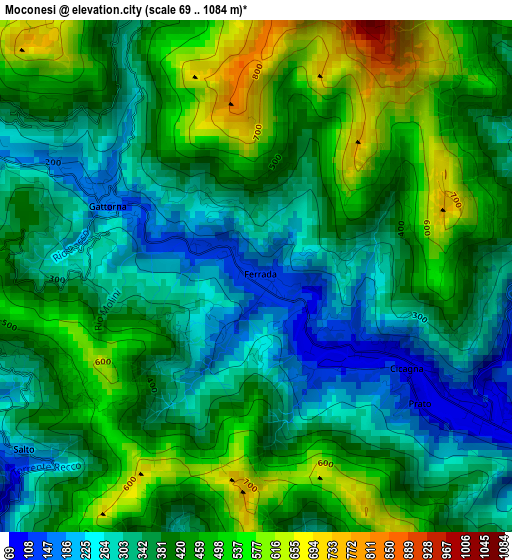
Below is the Elevation map of Moconesi, which displays elevation range with different colors. Scale of the first map is from 69 to 1084 m (226 to 3556 ft) with average elevation of 397.5 meters (=1304 ft) [note 1]
These maps also provides idea of topography and contour of this city, they are displayed at different zoom levels. More info about maps, scale and edge coordinates you can find below images.
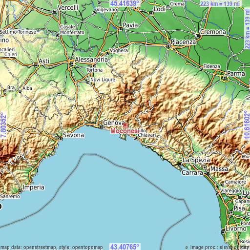
| \ | Map #1 | Topo.Map |
| Scale [m] | 69..1084 m | × |
| Scale [ft] | 226..3556 ft | × |
| Average | 397.5 m = 1304 ft | × |
| Width | 6.98 km = 4.3 mi | 223.4 km = 138.8 mi |
| Height | 6.98 km = 4.3 mi | 223.3 km = 138.8 mi |
| ↑Max Latitude | 44.452028° | 45.41639° |
| Latitude at center | 44.42065° | 44.42065° |
| ↓Min Latitude | 44.389255° | 43.40765° |
| ← Min Longitude | 9.165825° | 7.80352° |
| Longitude center | 9.20977° | 9.20977° |
| →Max Longitude | 9.253715° | 10.61602° |
Nearby cities:
Cities around Moconesi sort by population:
• Rapallo elevation 11 m
8 km,  169°
169°
• Uscio 350 m
3.9 km,  256°
256°
• Avegno 58 m
5.9 km,  224°
224°
• Cicagna 85 m
2.8 km,  122°
122°
• Ferrada 128 m
0.1 km,  153°
153°
• Tribogna 308 m
1.2 km,  247°
247°
• Favale di Malvaro 334 m
5.3 km,  49°
49°
• Lorsica 421 m
5.5 km,  74°
74°
• Neirone 391 m
4.1 km,  338°
338°
• Coreglia Ligure 297 m
5.5 km,  131°
131°
• Orero 430 m
4.8 km,  106°
106°
• Ferriere 262 m
6.3 km,  293°
293°
Multilingual:
 En español:
Moconesi elevación 139 m.
 En France:
Moconesi élévation 139 m.
 Auf Deutsch:
Moconesi höhe über dem Meeresspiegel ist 139 m.

Sources and notes:
- [note 1] Map square and city borders are not equal. Map elevation data is calculated only from area inside that square.
- [src 1] Elevation data from geonames database provided with same terms of usage.
- [src 2] The elevation map of Moconesi is generated using elevation data from NASA's 3 arcsec (90m) resolution SRTM data.
- [src 3] Base (background) map © OpenStreetMap contributors tiles are generated by Geofabrik and OpenTopoMap.
Copyright & License:
This Moconesi Elevation Map is licensed under CC BY-SA. You may reuse any part from this page, if you give a proper credit by linking to this URL:
 More info on terms of use page.