Pleyne elevation
Pleyne (Piedmont, Provincia di Cuneo), Italy elevation is 1594 meters and Pleyne elevation in feet is 5230 ft above sea level [src 1]. Pleyne is a seat of a third-order administrative division (feature code) with elevation that is 1272 meters (4173 ft) bigger than average city elevation in Italy.
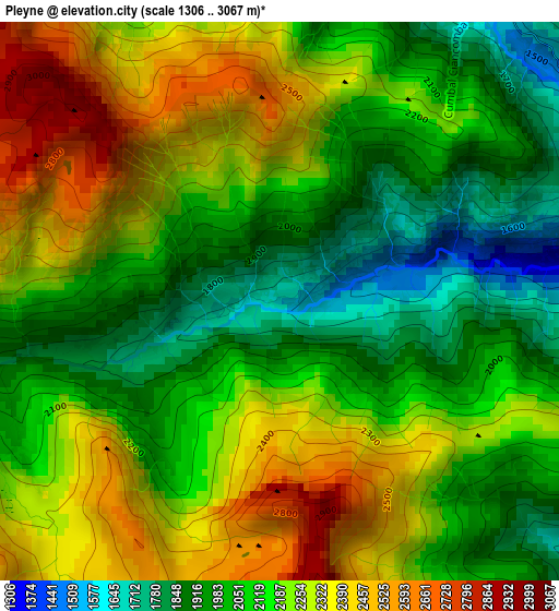
Below is the Elevation map of Pleyne, which displays elevation range with different colors. Scale of the first map is from 1306 to 3067 m (4285 to 10062 ft) with average elevation of 2156 meters (=7073 ft) [note 1]
These maps also provides idea of topography and contour of this city, they are displayed at different zoom levels. More info about maps, scale and edge coordinates you can find below images.
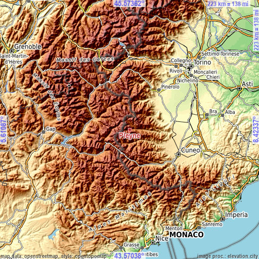
| \ | Map #1 | Topo.Map |
| Scale [m] | 1306..3067 m | × |
| Scale [ft] | 4285..10062 ft | × |
| Average | 2156 m = 7073 ft | × |
| Width | 6.96 km = 4.3 mi | 222.7 km = 138.4 mi |
| Height | 6.96 km = 4.3 mi | 222.7 km = 138.4 mi |
| ↑Max Latitude | 44.611922° | 45.57362° |
| Latitude at center | 44.58063° | 44.58063° |
| ↓Min Latitude | 44.549321° | 43.57038° |
| ← Min Longitude | 6.973175° | 5.61087° |
| Longitude center | 7.01712° | 7.01712° |
| →Max Longitude | 7.061065° | 8.42337° |
Nearby cities:
Cities around Pleyne sort by population:
• Sampeyre elevation 977 m
13.7 km,  91°
91°
• Crissolo 1343 m
17.2 km,  39°
39°
• Pontechianale 1594 m
4.6 km,  12°
12°
• Stroppo 1100 m
12 km,  133°
133°
• Casteldelfino 1314 m
4.3 km,  76°
76°
• Acceglio 1220 m
12 km,  189°
189°
• Prazzo Superiore 1051 m
11.3 km,  164°
164°
• Canosio 1260 m
14.8 km, 159°
• Macra 821 m
15.7 km,  124°
124°
• Marmora 1239 m
14.9 km, 155°
• Serre 1642 m
7.3 km, 127°
• Chiesa di Macra 1303 m
16.9 km, 130°
Multilingual:
 En español:
Pleyne elevación 1594 m.
 En France:
Pleyne élévation 1594 m.


Sources and notes:
- [note 1] Map square and city borders are not equal. Map elevation data is calculated only from area inside that square.
- [src 1] Elevation data from geonames database provided with same terms of usage.
- [src 2] The elevation map of Pleyne is generated using elevation data from NASA's 3 arcsec (90m) resolution SRTM data.
- [src 3] Base (background) map © OpenStreetMap contributors tiles are generated by Geofabrik and OpenTopoMap.
Copyright & License:
This Pleyne Elevation Map is licensed under CC BY-SA. You may reuse any part from this page, if you give a proper credit by linking to this URL:
 More info on terms of use page.