Roure elevation
Roure (Piedmont, Torino), Italy elevation is 897 meters and Roure elevation in feet is 2943 ft above sea level [src 1]. Roure is a seat of a third-order administrative division (feature code) with elevation that is 575 meters (1886 ft) bigger than average city elevation in Italy.
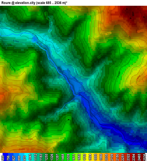
Below is the Elevation map of Roure, which displays elevation range with different colors. Scale of the first map is from 685 to 2536 m (2247 to 8320 ft) with average elevation of 1399.6 meters (=4592 ft) [note 1]
These maps also provides idea of topography and contour of this city, they are displayed at different zoom levels. More info about maps, scale and edge coordinates you can find below images.
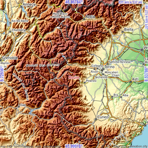
| \ | Map #1 | Topo.Map |
| Scale [m] | 685..2536 m | × |
| Scale [ft] | 2247..8320 ft | × |
| Average | 1399.6 m = 4592 ft | × |
| Width | 6.91 km = 4.3 mi | 221.1 km = 137.4 mi |
| Height | 6.91 km = 4.3 mi | 221.1 km = 137.4 mi |
| ↑Max Latitude | 45.033204° | 45.98784° |
| Latitude at center | 45.00214° | 45.00214° |
| ↓Min Latitude | 44.971059° | 43.99918° |
| ← Min Longitude | 7.087665° | 5.72536° |
| Longitude center | 7.13161° | 7.13161° |
| →Max Longitude | 7.175555° | 8.53786° |
Nearby cities:
Cities around Roure sort by population:
• Perosa Argentina elevation 641 m
6.7 km,  135°
135°
• Pinasca-Dubbione 549 m
10.1 km,  130°
130°
• Pomaretto 621 m
6.5 km, 142°
• Inverso Pinasca 548 m
9.3 km, 132°
• Mattie 732 m
13 km,  354°
354°
• Fleccia-Chianavasso 555 m
9 km, 133°
• Fenestrelle 1152 m
7.5 km,  300°
300°
• Pramollo 1071 m
11.4 km,  156°
156°
• Perrero 817 m
7.2 km,  191°
191°
• Salza di Pinerolo 1215 m
9.3 km,  222°
222°
• Massello 1188 m
7.6 km,  230°
230°
• Usseaux 1440 m
9.6 km, 302°
Multilingual:
 En español:
Roure elevación 897 m.
 En France:
Roure élévation 897 m.


Sources and notes:
- [note 1] Map square and city borders are not equal. Map elevation data is calculated only from area inside that square.
- [src 1] Elevation data from geonames database provided with same terms of usage.
- [src 2] The elevation map of Roure is generated using elevation data from NASA's 3 arcsec (90m) resolution SRTM data.
- [src 3] Base (background) map © OpenStreetMap contributors tiles are generated by Geofabrik and OpenTopoMap.
Copyright & License:
This Roure Elevation Map is licensed under CC BY-SA. You may reuse any part from this page, if you give a proper credit by linking to this URL:
 More info on terms of use page.