Belveglio elevation
Belveglio (Piedmont, Provincia di Asti), Italy elevation is 139 meters and Belveglio elevation in feet is 456 ft above sea level [src 1]. Belveglio is a seat of a third-order administrative division (feature code) with elevation that is 183 meters (600 ft) smaller than average city elevation in Italy.
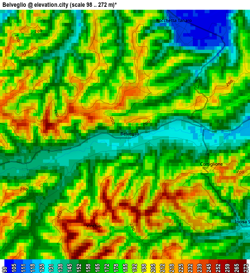
Below is the Elevation map of Belveglio, which displays elevation range with different colors. Scale of the first map is from 98 to 272 m (322 to 892 ft) with average elevation of 178.9 meters (=587 ft) [note 1]
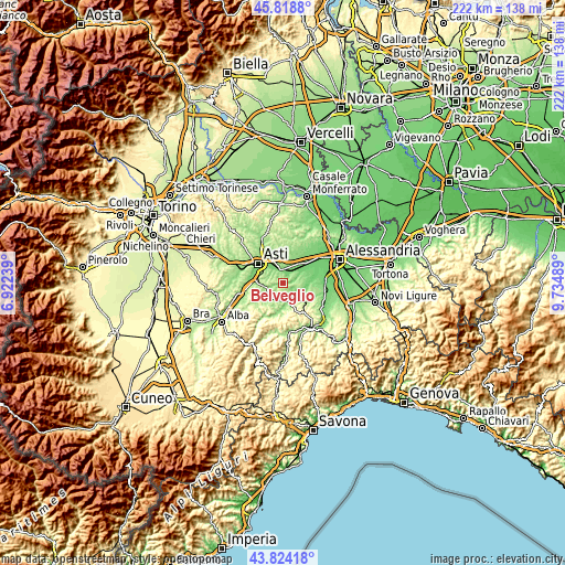
These maps also provides idea of topography and contour of this city, they are displayed at different zoom levels. More info about maps, scale and edge coordinates you can find below images.
| \ | Map #1 | Topo.Map |
| Scale [m] | 98..272 m | × |
| Scale [ft] | 322..892 ft | × |
| Average | 178.9 m = 587 ft | × |
| Width | 6.93 km = 4.3 mi | 221.8 km = 137.8 mi |
| Height | 6.93 km = 4.3 mi | 221.8 km = 137.8 mi |
| ↑Max Latitude | 44.861278° | 45.8188° |
| Latitude at center | 44.83012° | 44.83012° |
| ↓Min Latitude | 44.798946° | 43.82418° |
| ← Min Longitude | 8.284695° | 6.92239° |
| Longitude center | 8.32864° | 8.32864° |
| →Max Longitude | 8.372585° | 9.73489° |
Nearby cities:
Cities around Belveglio sort by population:
• Incisa Scapaccino elevation 129 m
4.5 km,  123°
123°
• Mombercelli 189 m
3 km,  242°
242°
• Ghiare-Madonna 130 m
4.4 km, 124°
• Castello di Annone 114 m
5.6 km,  350°
350°
• Rocchetta Tanaro 107 m
3.4 km,  22°
22°
• Cerro Tanaro 110 m
5.4 km,  26°
26°
• Vinchio 235 m
2.2 km,  195°
195°
• Montaldo Scarampi 271 m
5.5 km,  270°
270°
• Cortiglione 201 m
2.5 km,  110°
110°
• Castelnuovo Calcea 226 m
5.9 km,  216°
216°
• Rocca d'Arazzo 182 m
5.8 km,  323°
323°
• Vaglio Serra 271 m
3.8 km,  167°
167°
Multilingual:
 En español:
Belveglio elevación 139 m.
 En France:
Belveglio élévation 139 m.
 Auf Deutsch:
Belveglio höhe über dem Meeresspiegel ist 139 m.

Sources and notes:
- [note 1] Map square and city borders are not equal. Map elevation data is calculated only from area inside that square.
- [src 1] Elevation data from geonames database provided with same terms of usage.
- [src 2] The elevation map of Belveglio is generated using elevation data from NASA's 3 arcsec (90m) resolution SRTM data.
- [src 3] Base (background) map © OpenStreetMap contributors tiles are generated by Geofabrik and OpenTopoMap.
Copyright & License:
This Belveglio Elevation Map is licensed under CC BY-SA. You may reuse any part from this page, if you give a proper credit by linking to this URL:
 More info on terms of use page.