Tremestieri Etneo elevation
Tremestieri Etneo (Sicily, Catania), Italy elevation is 355 meters and Tremestieri Etneo elevation in feet is 1165 ft above sea level [src 1]. Tremestieri Etneo is a seat of a third-order administrative division (feature code) with elevation that is 33 meters (108 ft) bigger than average city elevation in Italy.
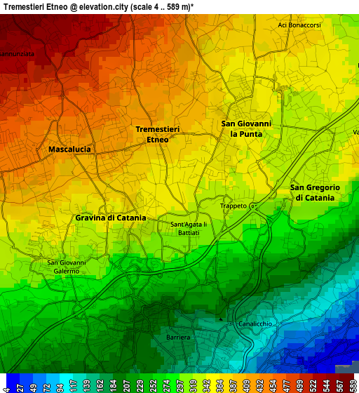
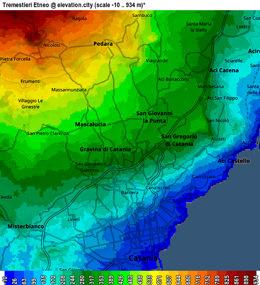
Below is the Elevation map of Tremestieri Etneo, which displays elevation range with different colors. Scale of the first map is from 4 to 589 m (13 to 1932 ft) with average elevation of 320.4 meters (=1051 ft) [note 1]
These maps also provides idea of topography and contour of this city, they are displayed at different zoom levels. More info about maps, scale and edge coordinates you can find below images.
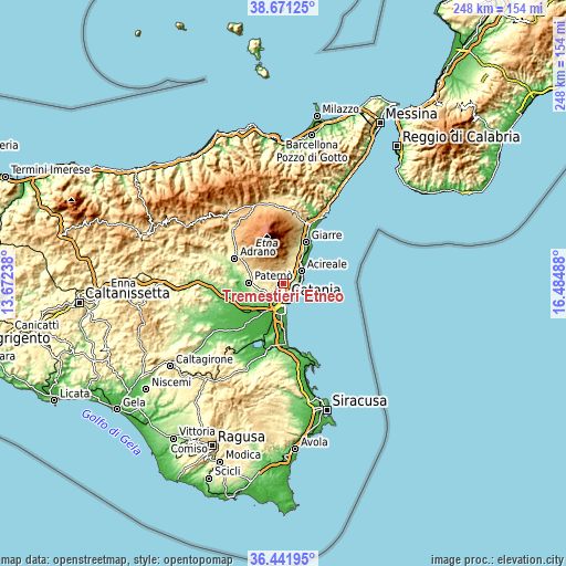
| \ | Map #1 | Map #2 | Topo.Map |
| Scale [m] | 4..589 m | -10..934 m | × |
| Scale [ft] | 13..1932 ft | -33..3064 ft | × |
| Average | 320.4 m = 1051 ft | 333.7 m = 1095 ft | × |
| Width | 7.75 km = 4.8 mi | 15.49 km = 9.6 mi | 247.9 km = 154 mi |
| Height | 7.75 km = 4.8 mi | 15.49 km = 9.6 mi | 247.9 km = 154 mi |
| ↑Max Latitude | 37.599766° | 37.634575° | 38.67125° |
| Latitude at center | 37.56494° | 37.56494° | 37.56494° |
| ↓Min Latitude | 37.530098° | 37.49524° | 36.44195° |
| ← Min Longitude | 15.034685° | 14.990739° | 13.67238° |
| Longitude center | 15.07863° | 15.07863° | 15.07863° |
| →Max Longitude | 15.122575° | 15.166521° | 16.48488° |
Nearby cities:
Cities around Tremestieri Etneo sort by population:
• Mascalucia elevation 425 m
2.8 km,  292°
292°
• Gravina di Catania 361 m
1.5 km,  251°
251°
• San Giovanni la Punta 353 m
1.9 km,  44°
44°
• Sant'Agata Li Battiati 314 m
0.8 km,  171°
171°
• Canalicchio 147 m
3.1 km,  149°
149°
• San Pietro Clarenza 447 m
4.9 km,  275°
275°
• San Gregorio di Catania 339 m
2.9 km,  84°
84°
• Valverde 347 m
4.2 km,  71°
71°
• Carrubazza-Motta 240 m
2.9 km,  116°
116°
• Aci Bonaccorsi 364 m
4.3 km, 35°
• Cerza 133 m
3.4 km,  136°
136°
• Maugeri 348 m
4.2 km,  55°
55°
Multilingual:
 En español:
Tremestieri Etneo elevación 355 m.
 En France:
Tremestieri Etneo élévation 355 m.
 Auf Deutsch:
Tremestieri Etneo höhe über dem Meeresspiegel ist 355 m.

Sources and notes:
- [note 1] Map square and city borders are not equal. Map elevation data is calculated only from area inside that square.
- [src 1] Elevation data from geonames database provided with same terms of usage.
- [src 2] The elevation map of Tremestieri Etneo is generated using elevation data from NASA's 3 arcsec (90m) resolution SRTM data.
- [src 3] Base (background) map © OpenStreetMap contributors tiles are generated by Geofabrik and OpenTopoMap.
Copyright & License:
This Tremestieri Etneo Elevation Map is licensed under CC BY-SA. You may reuse any part from this page, if you give a proper credit by linking to this URL:
 More info on terms of use page.