Pero elevation
Pero (Lombardy, Città metropolitana di Milano), Italy elevation is 143 meters and Pero elevation in feet is 469 ft above sea level [src 1]. Pero is a seat of a third-order administrative division (feature code) with elevation that is 179 meters (587 ft) smaller than average city elevation in Italy.
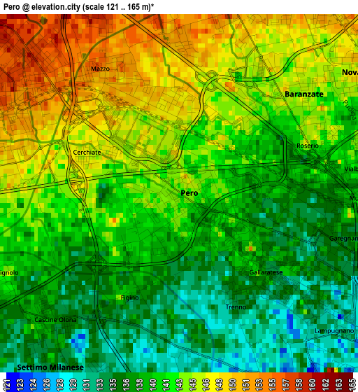
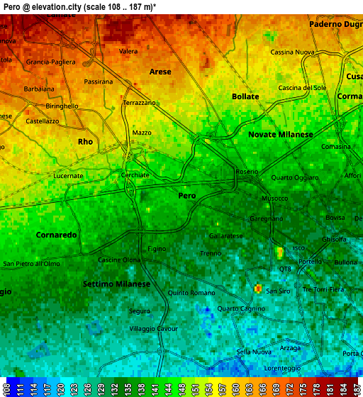
Below is the Elevation map of Pero, which displays elevation range with different colors. Scale of the first map is from 121 to 165 m (397 to 541 ft) with average elevation of 141.3 meters (=464 ft) [note 1]
These maps also provides idea of topography and contour of this city, they are displayed at different zoom levels. More info about maps, scale and edge coordinates you can find below images.
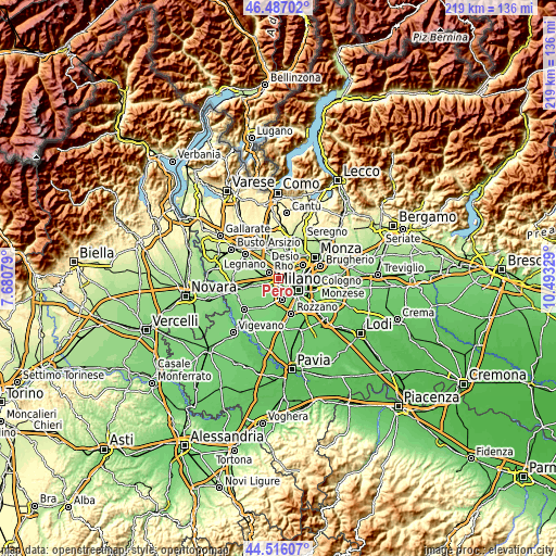
| \ | Map #1 | Map #2 | Topo.Map |
| Scale [m] | 121..165 m | 108..187 m | × |
| Scale [ft] | 397..541 ft | 354..614 ft | × |
| Average | 141.3 m = 464 ft | 143.8 m = 472 ft | × |
| Width | 6.85 km = 4.3 mi | 13.7 km = 8.5 mi | 219.1 km = 136.1 mi |
| Height | 6.85 km = 4.3 mi | 13.7 km = 8.5 mi | 219.1 km = 136.1 mi |
| ↑Max Latitude | 45.540958° | 45.571729° | 46.48702° |
| Latitude at center | 45.51017° | 45.51017° | 45.51017° |
| ↓Min Latitude | 45.479365° | 45.448544° | 44.51607° |
| ← Min Longitude | 9.043095° | 8.999149° | 7.68079° |
| Longitude center | 9.08704° | 9.08704° | 9.08704° |
| →Max Longitude | 9.130985° | 9.174931° | 10.49329° |
Nearby cities:
Cities around Pero sort by population:
• Rho elevation 160 m
4.4 km,  304°
304°
• Bollate 155 m
4.8 km,  32°
32°
• Cornaredo 147 m
4.8 km,  258°
258°
• Novate Milanese 149 m
4.7 km,  61°
61°
• Cormano 154 m
7.1 km,  52°
52°
• Arese 162 m
4.5 km,  350°
350°
• Settimo Milanese 134 m
4.4 km,  214°
214°
• Baranzate 146 m
3 km, 51°
• Pregnana Milanese 153 m
6.3 km,  275°
275°
• Vighignolo 143 m
3.8 km,  244°
244°
• Passirana 164 m
5.4 km,  321°
321°
• Figino 137 m
2.1 km,  200°
200°
Multilingual:
 En español:
Pero elevación 143 m.
 En France:
Pero élévation 143 m.


Sources and notes:
- [note 1] Map square and city borders are not equal. Map elevation data is calculated only from area inside that square.
- [src 1] Elevation data from geonames database provided with same terms of usage.
- [src 2] The elevation map of Pero is generated using elevation data from NASA's 3 arcsec (90m) resolution SRTM data.
- [src 3] Base (background) map © OpenStreetMap contributors tiles are generated by Geofabrik and OpenTopoMap.
Copyright & License:
This Pero Elevation Map is licensed under CC BY-SA. You may reuse any part from this page, if you give a proper credit by linking to this URL:
 More info on terms of use page.