Agliè elevation
Agliè (Piedmont, Torino), Italy elevation is 337 meters and Agliè elevation in feet is 1106 ft above sea level [src 1]. Agliè is a seat of a third-order administrative division (feature code) with elevation that is 15 meters (49 ft) bigger than average city elevation in Italy.
Below is the Elevation map of Agliè, which displays elevation range with different colors. Scale of the first map is from 273 to 522 m (896 to 1713 ft) with average elevation of 347.1 meters (=1139 ft) [note 1]
These maps also provides idea of topography and contour of this city, they are displayed at different zoom levels. More info about maps, scale and edge coordinates you can find below images.
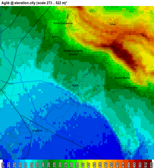
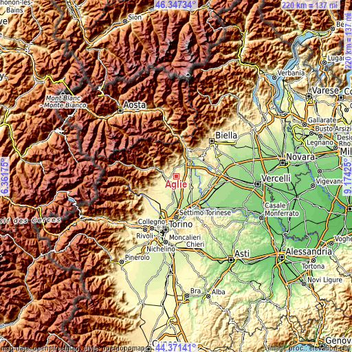
| \ | Map #1 | Topo.Map |
| Scale [m] | 273..522 m | × |
| Scale [ft] | 896..1713 ft | × |
| Average | 347.1 m = 1139 ft | × |
| Width | 6.87 km = 4.3 mi | 219.7 km = 136.5 mi |
| Height | 6.87 km = 4.3 mi | 219.7 km = 136.5 mi |
| ↑Max Latitude | 45.398865° | 46.34734° |
| Latitude at center | 45.368° | 45.368° |
| ↓Min Latitude | 45.337118° | 44.37141° |
| ← Min Longitude | 7.724055° | 6.36175° |
| Longitude center | 7.768° | 7.768° |
| →Max Longitude | 7.811945° | 9.17425° |
Nearby cities:
Cities around Agliè sort by population:
• Rivarolo Canavese elevation 304 m
5.7 km,  219°
219°
• Castellamonte 348 m
4.9 km,  289°
289°
• San Giorgio Canavese 283 m
4.3 km,  146°
146°
• Ozegna 300 m
2.9 km, 218°
• Cuceglio 358 m
3.9 km,  105°
105°
• Bairo 369 m
2.2 km,  333°
333°
• Lusigliè 270 m
5.5 km,  182°
182°
• Torre Canavese 389 m
2.8 km,  346°
346°
• San Martino Canavese 398 m
4.8 km,  51°
51°
• Ciconio 278 m
4.3 km,  190°
190°
• Vialfrè 482 m
4.2 km,  70°
70°
• Baldissero Canavese 391 m
5.1 km,  338°
338°
Multilingual:
 En español:
Agliè elevación 337 m.
 En France:
Agliè élévation 337 m.


Sources and notes:
- [note 1] Map square and city borders are not equal. Map elevation data is calculated only from area inside that square.
- [src 1] Elevation data from geonames database provided with same terms of usage.
- [src 2] The elevation map of Agliè is generated using elevation data from NASA's 3 arcsec (90m) resolution SRTM data.
- [src 3] Base (background) map © OpenStreetMap contributors tiles are generated by Geofabrik and OpenTopoMap.
Copyright & License:
This Agliè Elevation Map is licensed under CC BY-SA. You may reuse any part from this page, if you give a proper credit by linking to this URL:
 More info on terms of use page.