Albenga elevation
Albenga (Liguria, Provincia di Savona), Italy elevation is 4 meters and Albenga elevation in feet is 13 ft above sea level [src 1]. Albenga is a seat of a third-order administrative division (feature code) with elevation that is 318 meters (1043 ft) smaller than average city elevation in Italy.
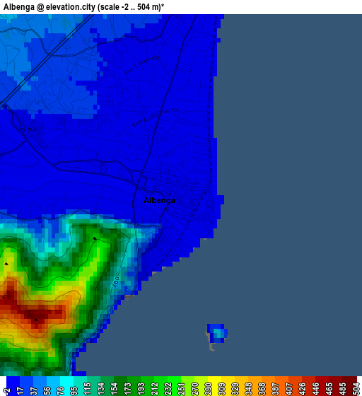
Below is the Elevation map of Albenga, which displays elevation range with different colors. Scale of the first map is from -2 to 504 m (-7 to 1654 ft) with average elevation of 64.6 meters (=212 ft) [note 1]
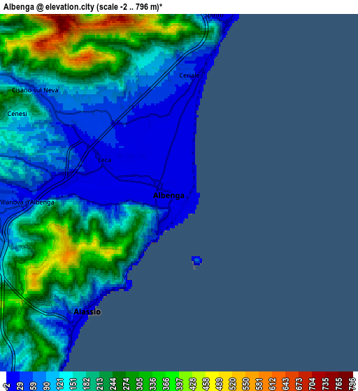
These maps also provides idea of topography and contour of this city, they are displayed at different zoom levels. More info about maps, scale and edge coordinates you can find below images.
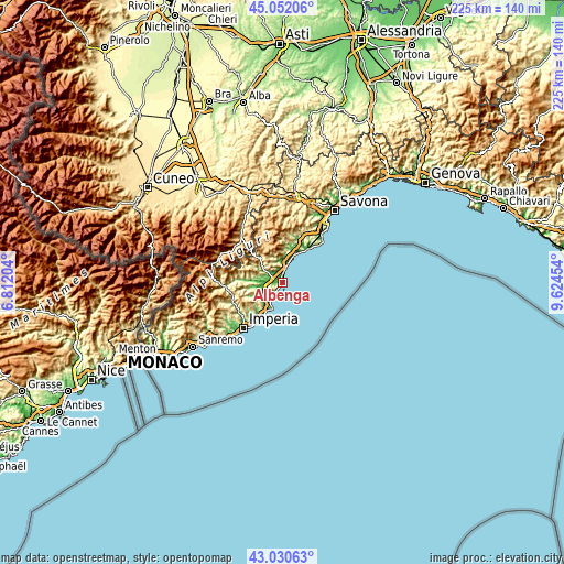
| \ | Map #1 | Map #2 | Topo.Map |
| Scale [m] | -2..504 m | -2..796 m | × |
| Scale [ft] | -7..1654 ft | -7..2612 ft | × |
| Average | 64.6 m = 212 ft | 169.8 m = 557 ft | × |
| Width | 7.02 km = 4.4 mi | 14.05 km = 8.7 mi | 224.8 km = 139.7 mi |
| Height | 7.02 km = 4.4 mi | 14.05 km = 8.7 mi | 224.8 km = 139.7 mi |
| ↑Max Latitude | 44.081547° | 44.113106° | 45.05206° |
| Latitude at center | 44.04997° | 44.04997° | 44.04997° |
| ↓Min Latitude | 44.018377° | 43.986766° | 43.03063° |
| ← Min Longitude | 8.174345° | 8.130399° | 6.81204° |
| Longitude center | 8.21829° | 8.21829° | 8.21829° |
| →Max Longitude | 8.262235° | 8.306181° | 9.62454° |
Nearby cities:
Cities around Albenga sort by population:
• Loano elevation 13 m
9.2 km,  19°
19°
• Alassio 12 m
6.6 km,  218°
218°
• Ceriale 9 m
4.7 km,  10°
10°
• Borghetto Santo Spirito 6 m
7.1 km, 14°
• Toirano 49 m
8.6 km,  354°
354°
• Villanova d'Albenga 34 m
6 km,  267°
267°
• San Fedele-Lusignano 16 m
3 km,  260°
260°
• Campochiesa 17 m
2.9 km,  323°
323°
• Villafranca 55 m
9.2 km, 258°
• Cisano 54 m
6.9 km,  305°
305°
• Balestrino 365 m
9.1 km,  335°
335°
• Chiesa 264 m
9.3 km,  289°
289°
Multilingual:
 En español:
Albenga elevación 4 m.
 En France:
Albenga élévation 4 m.


Sources and notes:
- [note 1] Map square and city borders are not equal. Map elevation data is calculated only from area inside that square.
- [src 1] Elevation data from geonames database provided with same terms of usage.
- [src 2] The elevation map of Albenga is generated using elevation data from NASA's 3 arcsec (90m) resolution SRTM data.
- [src 3] Base (background) map © OpenStreetMap contributors tiles are generated by Geofabrik and OpenTopoMap.
Copyright & License:
This Albenga Elevation Map is licensed under CC BY-SA. You may reuse any part from this page, if you give a proper credit by linking to this URL:
 More info on terms of use page.