Asso elevation
Asso (Lombardy, Provincia di Como), Italy elevation is 428 meters and Asso elevation in feet is 1404 ft above sea level [src 1]. Asso is a seat of a third-order administrative division (feature code) with elevation that is 106 meters (348 ft) bigger than average city elevation in Italy.
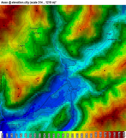
Below is the Elevation map of Asso, which displays elevation range with different colors. Scale of the first map is from 314 to 1210 m (1030 to 3970 ft) with average elevation of 686.7 meters (=2253 ft) [note 1]
These maps also provides idea of topography and contour of this city, they are displayed at different zoom levels. More info about maps, scale and edge coordinates you can find below images.
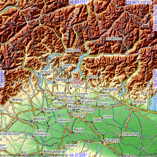
| \ | Map #1 | Topo.Map |
| Scale [m] | 314..1210 m | × |
| Scale [ft] | 1030..3970 ft | × |
| Average | 686.7 m = 2253 ft | × |
| Width | 6.81 km = 4.2 mi | 217.8 km = 135.3 mi |
| Height | 6.81 km = 4.2 mi | 217.8 km = 135.3 mi |
| ↑Max Latitude | 45.891205° | 46.83131° |
| Latitude at center | 45.86061° | 45.86061° |
| ↓Min Latitude | 45.829998° | 44.87266° |
| ← Min Longitude | 9.223355° | 7.86105° |
| Longitude center | 9.2673° | 9.2673° |
| →Max Longitude | 9.311245° | 10.67355° |
Nearby cities:
Cities around Asso sort by population:
• Canzo elevation 393 m
1.4 km,  169°
169°
• Ponte Lambro 299 m
5.1 km,  220°
220°
• Osigo 494 m
2.7 km,  53°
53°
• Valbrona 485 m
3.1 km, 52°
• Corneno-Galliano-Carella Mariaga 357 m
4.9 km,  180°
180°
• Caslino d'Erba 422 m
4 km,  233°
233°
• Castelmarte 455 m
4.1 km, 220°
• Proserpio 469 m
4 km,  205°
205°
• Sormano 778 m
2.6 km,  319°
319°
• Lasnigo 558 m
2.4 km,  358°
358°
• Caglio 794 m
2.6 km,  297°
297°
• Rezzago 669 m
1.6 km, 295°
Multilingual:
 En español:
Asso elevación 428 m.
 En France:
Asso élévation 428 m.


Sources and notes:
- [note 1] Map square and city borders are not equal. Map elevation data is calculated only from area inside that square.
- [src 1] Elevation data from geonames database provided with same terms of usage.
- [src 2] The elevation map of Asso is generated using elevation data from NASA's 3 arcsec (90m) resolution SRTM data.
- [src 3] Base (background) map © OpenStreetMap contributors tiles are generated by Geofabrik and OpenTopoMap.
Copyright & License:
This Asso Elevation Map is licensed under CC BY-SA. You may reuse any part from this page, if you give a proper credit by linking to this URL:
 More info on terms of use page.