Aurigo elevation
Aurigo (Liguria, Provincia di Imperia), Italy elevation is 420 meters and Aurigo elevation in feet is 1378 ft above sea level [src 1]. Aurigo is a seat of a third-order administrative division (feature code) with elevation that is 98 meters (322 ft) bigger than average city elevation in Italy.
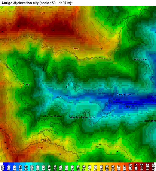
Below is the Elevation map of Aurigo, which displays elevation range with different colors. Scale of the first map is from 159 to 1197 m (522 to 3927 ft) with average elevation of 634.4 meters (=2081 ft) [note 1]
These maps also provides idea of topography and contour of this city, they are displayed at different zoom levels. More info about maps, scale and edge coordinates you can find below images.
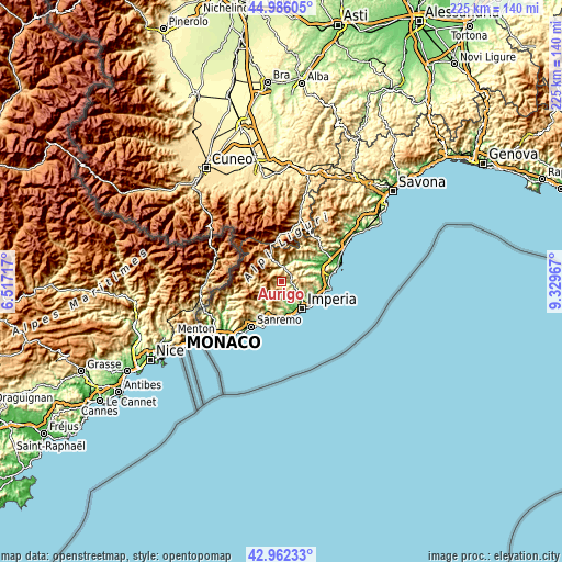
| \ | Map #1 | Topo.Map |
| Scale [m] | 159..1197 m | × |
| Scale [ft] | 522..3927 ft | × |
| Average | 634.4 m = 2081 ft | × |
| Width | 7.03 km = 4.4 mi | 225 km = 139.8 mi |
| Height | 7.03 km = 4.4 mi | 225 km = 139.8 mi |
| ↑Max Latitude | 44.014422° | 44.98605° |
| Latitude at center | 43.98281° | 43.98281° |
| ↓Min Latitude | 43.951181° | 42.96233° |
| ← Min Longitude | 7.879475° | 6.51717° |
| Longitude center | 7.92342° | 7.92342° |
| →Max Longitude | 7.967365° | 9.32967° |
Nearby cities:
Cities around Aurigo sort by population:
• Pieve di Teco elevation 263 m
7.2 km,  355°
355°
• Borgomaro 194 m
1.9 km,  116°
116°
• Chiusavecchia 145 m
5.2 km,  109°
109°
• Caravonica 374 m
3 km,  67°
67°
• Rezzo 554 m
5.9 km,  315°
315°
• Chiusanico 375 m
5.6 km,  101°
101°
• Vasia 367 m
6.1 km,  156°
156°
• Lucinasco 485 m
3.5 km, 122°
• Cesio 527 m
5 km,  55°
55°
• Carpasio 708 m
5.2 km,  241°
241°
• Molini 155 m
6.4 km,  169°
169°
• Prelà Castello 326 m
5 km, 160°
Multilingual:
 En español:
Aurigo elevación 420 m.
 En France:
Aurigo élévation 420 m.


Sources and notes:
- [note 1] Map square and city borders are not equal. Map elevation data is calculated only from area inside that square.
- [src 1] Elevation data from geonames database provided with same terms of usage.
- [src 2] The elevation map of Aurigo is generated using elevation data from NASA's 3 arcsec (90m) resolution SRTM data.
- [src 3] Base (background) map © OpenStreetMap contributors tiles are generated by Geofabrik and OpenTopoMap.
Copyright & License:
This Aurigo Elevation Map is licensed under CC BY-SA. You may reuse any part from this page, if you give a proper credit by linking to this URL:
 More info on terms of use page.