Bagnone elevation
Bagnone (Tuscany, Provincia di Massa-Carrara), Italy elevation is 249 meters and Bagnone elevation in feet is 817 ft above sea level [src 1]. Bagnone is a seat of a third-order administrative division (feature code) with elevation that is 73 meters (240 ft) smaller than average city elevation in Italy.
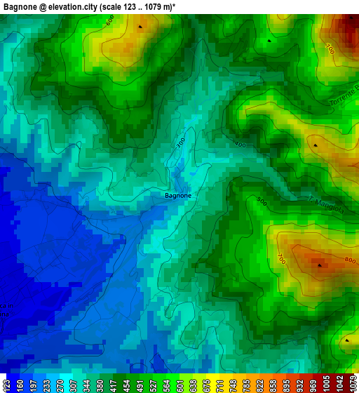
Below is the Elevation map of Bagnone, which displays elevation range with different colors. Scale of the first map is from 123 to 1079 m (404 to 3540 ft) with average elevation of 401.9 meters (=1319 ft) [note 1]
These maps also provides idea of topography and contour of this city, they are displayed at different zoom levels. More info about maps, scale and edge coordinates you can find below images.
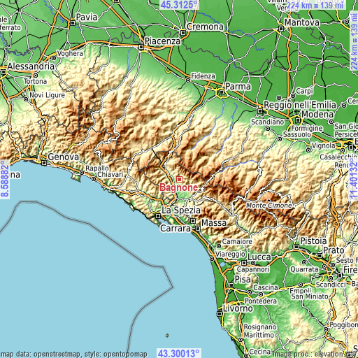
| \ | Map #1 | Topo.Map |
| Scale [m] | 123..1079 m | × |
| Scale [ft] | 404..3540 ft | × |
| Average | 401.9 m = 1319 ft | × |
| Width | 6.99 km = 4.3 mi | 223.8 km = 139.1 mi |
| Height | 6.99 km = 4.3 mi | 223.7 km = 139 mi |
| ↑Max Latitude | 44.346375° | 45.3125° |
| Latitude at center | 44.31494° | 44.31494° |
| ↓Min Latitude | 44.283488° | 43.30013° |
| ← Min Longitude | 9.951125° | 8.58882° |
| Longitude center | 9.99507° | 9.99507° |
| →Max Longitude | 10.039015° | 11.40132° |
Nearby cities:
Cities around Bagnone sort by population:
• Pontremoli elevation 245 m
11.4 km,  305°
305°
• Aulla 60 m
12.1 km,  186°
186°
• Villafranca in Lunigiana 149 m
3.8 km,  241°
241°
• Monti 154 m
7.4 km,  171°
171°
• Terrarossa 84 m
9.4 km,  196°
196°
• Pallerone 78 m
12.3 km,  177°
177°
• Barbarasco 112 m
9.1 km,  205°
205°
• Filattiera 154 m
5.2 km,  288°
288°
• Licciana Nardi 210 m
6.5 km,  148°
148°
• Comano 535 m
11.1 km,  102°
102°
• Mulazzo 318 m
8.3 km,  270°
270°
• Tresana 160 m
9.4 km,  224°
224°
Multilingual:
 En español:
Bagnone elevación 249 m.
 En France:
Bagnone élévation 249 m.


Sources and notes:
- [note 1] Map square and city borders are not equal. Map elevation data is calculated only from area inside that square.
- [src 1] Elevation data from geonames database provided with same terms of usage.
- [src 2] The elevation map of Bagnone is generated using elevation data from NASA's 3 arcsec (90m) resolution SRTM data.
- [src 3] Base (background) map © OpenStreetMap contributors tiles are generated by Geofabrik and OpenTopoMap.
Copyright & License:
This Bagnone Elevation Map is licensed under CC BY-SA. You may reuse any part from this page, if you give a proper credit by linking to this URL:
 More info on terms of use page.