Baunei elevation
Baunei (Sardinia, Provincia di Nuoro), Italy elevation is 482 meters and Baunei elevation in feet is 1581 ft above sea level [src 1]. Baunei is a seat of a third-order administrative division (feature code) with elevation that is 160 meters (525 ft) bigger than average city elevation in Italy.
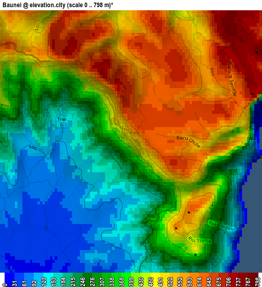
Below is the Elevation map of Baunei, which displays elevation range with different colors. Scale of the first map is from 0 to 798 m (0 to 2618 ft) with average elevation of 374.6 meters (=1229 ft) [note 1]
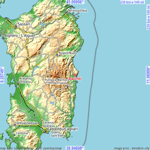
These maps also provides idea of topography and contour of this city, they are displayed at different zoom levels. More info about maps, scale and edge coordinates you can find below images.
| \ | Map #1 | Topo.Map |
| Scale [m] | 0..798 m | × |
| Scale [ft] | 0..2618 ft | × |
| Average | 374.6 m = 1229 ft | × |
| Width | 7.48 km = 4.6 mi | 239.4 km = 148.8 mi |
| Height | 7.48 km = 4.6 mi | 239.4 km = 148.8 mi |
| ↑Max Latitude | 40.06496° | 41.09956° |
| Latitude at center | 40.03132° | 40.03132° |
| ↓Min Latitude | 39.997663° | 38.94608° |
| ← Min Longitude | 9.619795° | 8.25749° |
| Longitude center | 9.66374° | 9.66374° |
| →Max Longitude | 9.707685° | 11.06999° |
Nearby cities:
Cities around Baunei sort by population:
• Tortolì elevation 19 m
11.7 km,  183°
183°
• Villagrande Strisaili 648 m
15.4 km,  238°
238°
• Arzana 678 m
17.2 km,  222°
222°
• Arbatax 16 m
11.3 km,  161°
161°
• Ilbono 422 m
18.4 km,  213°
213°
• Lotzorai 10 m
6.9 km, 180°
• Santa Maria Navarrese 33 m
4.9 km, 159°
• Urzulei 504 m
14.9 km,  297°
297°
• Talana 696 m
14.4 km,  274°
274°
• Triei 119 m
2.1 km,  281°
281°
• Girasole 9 m
8.8 km, 181°
• Elini 476 m
18.5 km, 217°
Multilingual:
 En español:
Baunei elevación 482 m.
 En France:
Baunei élévation 482 m.


Sources and notes:
- [note 1] Map square and city borders are not equal. Map elevation data is calculated only from area inside that square.
- [src 1] Elevation data from geonames database provided with same terms of usage.
- [src 2] The elevation map of Baunei is generated using elevation data from NASA's 3 arcsec (90m) resolution SRTM data.
- [src 3] Base (background) map © OpenStreetMap contributors tiles are generated by Geofabrik and OpenTopoMap.
Copyright & License:
This Baunei Elevation Map is licensed under CC BY-SA. You may reuse any part from this page, if you give a proper credit by linking to this URL:
 More info on terms of use page.