Calvi dell'Umbria elevation
Calvi dell'Umbria (Umbria, Provincia di Terni), Italy elevation is 399 meters and Calvi dell'Umbria elevation in feet is 1309 ft above sea level [src 1]. Calvi dell'Umbria is a seat of a third-order administrative division (feature code) with elevation that is 77 meters (253 ft) bigger than average city elevation in Italy.
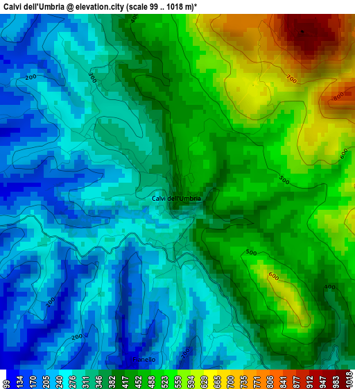
Below is the Elevation map of Calvi dell'Umbria, which displays elevation range with different colors. Scale of the first map is from 99 to 1018 m (325 to 3340 ft) with average elevation of 382 meters (=1253 ft) [note 1]
These maps also provides idea of topography and contour of this city, they are displayed at different zoom levels. More info about maps, scale and edge coordinates you can find below images.
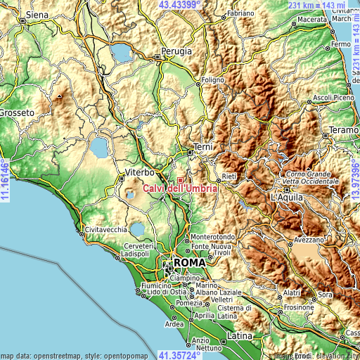
| \ | Map #1 | Topo.Map |
| Scale [m] | 99..1018 m | × |
| Scale [ft] | 325..3340 ft | × |
| Average | 382 m = 1253 ft | × |
| Width | 7.22 km = 4.5 mi | 230.9 km = 143.5 mi |
| Height | 7.22 km = 4.5 mi | 230.9 km = 143.5 mi |
| ↑Max Latitude | 42.436651° | 43.43399° |
| Latitude at center | 42.40421° | 42.40421° |
| ↓Min Latitude | 42.371752° | 41.35724° |
| ← Min Longitude | 12.523765° | 11.16146° |
| Longitude center | 12.56771° | 12.56771° |
| →Max Longitude | 12.611655° | 13.97396° |
Nearby cities:
Cities around Calvi dell'Umbria sort by population:
• Magliano Sabina elevation 178 m
8 km,  237°
237°
• Stimigliano 209 m
11.5 km,  181°
181°
• Otricoli 191 m
7.6 km,  283°
283°
• Collevecchio 226 m
7.9 km,  188°
188°
• Casperia 390 m
11.1 km,  130°
130°
• Torri in Sabina 277 m
8.5 km, 134°
• Montebuono 316 m
4.7 km,  149°
149°
• Tarano 230 m
5.8 km,  157°
157°
• Cottanello 502 m
9.7 km,  87°
87°
• Configni 487 m
6.7 km,  69°
69°
• Vacone 392 m
6.9 km,  112°
112°
• Montasola 575 m
9.6 km,  102°
102°
Multilingual:
 En español:
Calvi dell'Umbria elevación 399 m.
 En France:
Calvi dell'Umbria élévation 399 m.
 Auf Deutsch:
Calvi dell'Umbria höhe über dem Meeresspiegel ist 399 m.

Sources and notes:
- [note 1] Map square and city borders are not equal. Map elevation data is calculated only from area inside that square.
- [src 1] Elevation data from geonames database provided with same terms of usage.
- [src 2] The elevation map of Calvi dell'Umbria is generated using elevation data from NASA's 3 arcsec (90m) resolution SRTM data.
- [src 3] Base (background) map © OpenStreetMap contributors tiles are generated by Geofabrik and OpenTopoMap.
Copyright & License:
This Calvi dell'Umbria Elevation Map is licensed under CC BY-SA. You may reuse any part from this page, if you give a proper credit by linking to this URL:
 More info on terms of use page.