Camerata Picena elevation
Camerata Picena (The Marches, Provincia di Ancona), Italy elevation is 112 meters and Camerata Picena elevation in feet is 367 ft above sea level [src 1]. Camerata Picena is a seat of a third-order administrative division (feature code) with elevation that is 210 meters (689 ft) smaller than average city elevation in Italy.
Below is the Elevation map of Camerata Picena, which displays elevation range with different colors. Scale of the first map is from 4 to 190 m (13 to 623 ft) with average elevation of 51.4 meters (=169 ft) [note 1]
These maps also provides idea of topography and contour of this city, they are displayed at different zoom levels. More info about maps, scale and edge coordinates you can find below images.
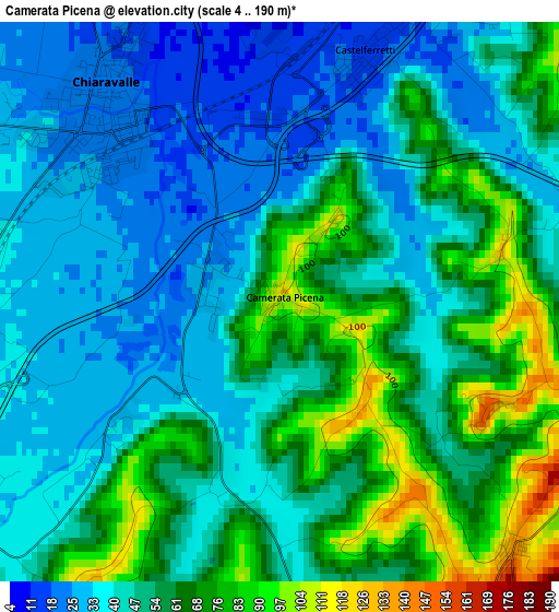
| \ | Map #1 | Topo.Map |
| Scale [m] | 4..190 m | × |
| Scale [ft] | 13..623 ft | × |
| Average | 51.4 m = 169 ft | × |
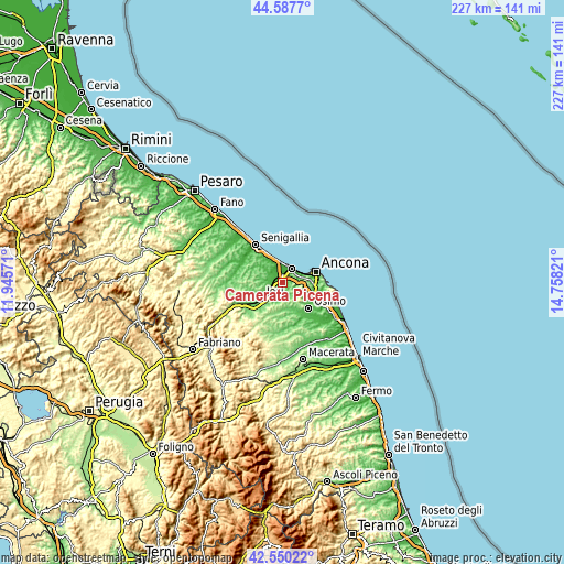
| Width | 7.08 km = 4.4 mi | 226.5 km = 140.7 mi |
| Height | 7.08 km = 4.4 mi | 226.5 km = 140.7 mi |
| ↑Max Latitude | 43.609407° | 44.5877° |
| Latitude at center | 43.57758° | 43.57758° |
| ↓Min Latitude | 43.545736° | 42.55022° |
| ← Min Longitude | 13.308015° | 11.94571° |
| Longitude center | 13.35196° | 13.35196° |
| →Max Longitude | 13.395905° | 14.75821° |
Nearby cities:
Cities around Camerata Picena sort by population:
• Jesi elevation 95 m
10.7 km,  234°
234°
• Falconara Marittima 39 m
6.6 km,  35°
35°
• Chiaravalle 23 m
3.4 km,  320°
320°
• Marina di Montemarciano 29 m
8.2 km,  351°
351°
• Santa Maria Nuova 251 m
9.8 km,  193°
193°
• Agugliano 196 m
4.6 km,  144°
144°
• Borghetto 52 m
5.3 km,  295°
295°
• Polverigi 56 m
6 km,  155°
155°
• Montemarciano 76 m
7.6 km,  332°
332°
• Monsano 162 m
8.2 km,  258°
258°
• Monte San Vito 139 m
7.2 km,  290°
290°
• Offagna 270 m
9.2 km,  128°
128°
Multilingual:
 En español:
Camerata Picena elevación 112 m.
 En France:
Camerata Picena élévation 112 m.
 Auf Deutsch:
Camerata Picena höhe über dem Meeresspiegel ist 112 m.

Sources and notes:
- [note 1] Map square and city borders are not equal. Map elevation data is calculated only from area inside that square.
- [src 1] Elevation data from geonames database provided with same terms of usage.
- [src 2] The elevation map of Camerata Picena is generated using elevation data from NASA's 3 arcsec (90m) resolution SRTM data.
- [src 3] Base (background) map © OpenStreetMap contributors tiles are generated by Geofabrik and OpenTopoMap.
Copyright & License:
This Camerata Picena Elevation Map is licensed under CC BY-SA. You may reuse any part from this page, if you give a proper credit by linking to this URL:
 More info on terms of use page.