Campoleone elevation
Campoleone (Latium, Provincia di Latina), Italy elevation is 133 meters and Campoleone elevation in feet is 436 ft above sea level [src 1]. Campoleone is a populated place (feature code) with elevation that is 189 meters (620 ft) smaller than average city elevation in Italy.
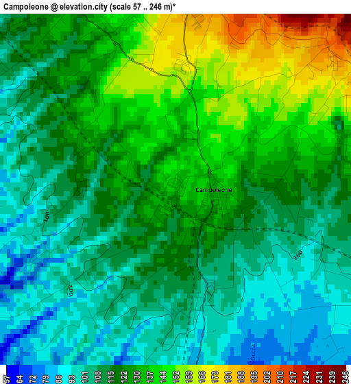
Below is the Elevation map of Campoleone, which displays elevation range with different colors. Scale of the first map is from 57 to 246 m (187 to 807 ft) with average elevation of 121 meters (=397 ft) [note 1]
These maps also provides idea of topography and contour of this city, they are displayed at different zoom levels. More info about maps, scale and edge coordinates you can find below images.
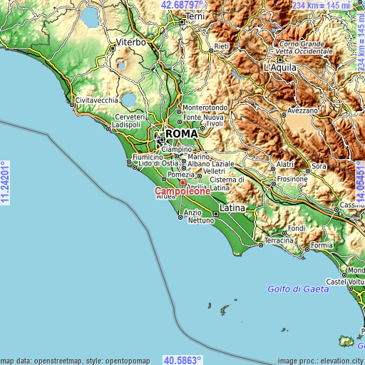
| \ | Map #1 | Topo.Map |
| Scale [m] | 57..246 m | × |
| Scale [ft] | 187..807 ft | × |
| Average | 121 m = 397 ft | × |
| Width | 7.3 km = 4.5 mi | 233.7 km = 145.2 mi |
| Height | 7.3 km = 4.5 mi | 233.7 km = 145.2 mi |
| ↑Max Latitude | 41.678531° | 42.68797° |
| Latitude at center | 41.6457° | 41.6457° |
| ↓Min Latitude | 41.612853° | 40.5863° |
| ← Min Longitude | 12.604315° | 11.24201° |
| Longitude center | 12.64826° | 12.64826° |
| →Max Longitude | 12.692205° | 14.05451° |
Nearby cities:
Cities around Campoleone sort by population:
• Aprilia elevation 79 m
5.7 km,  175°
175°
• Albano Laziale 382 m
9.1 km,  5°
5°
• Genzano di Roma 442 m
7.6 km,  26°
26°
• Ariccia 415 m
8.6 km, 13°
• Ardea 14 m
9.8 km,  244°
244°
• Cecchina 266 m
6.2 km,  1°
1°
• Lanuvio 276 m
4.9 km,  51°
51°
• Pavona 199 m
9.3 km,  343°
343°
• Fossignano 52 m
9.2 km,  229°
229°
• Casalazzara 63 m
6.5 km,  247°
247°
• Mantiglia di Ardea 118 m
4.5 km,  321°
321°
• Camilleri-Vallelata 74 m
5.8 km,  206°
206°
Multilingual:
 En español:
Campoleone elevación 133 m.
 En France:
Campoleone élévation 133 m.
 Auf Deutsch:
Campoleone höhe über dem Meeresspiegel ist 133 m.

Sources and notes:
- [note 1] Map square and city borders are not equal. Map elevation data is calculated only from area inside that square.
- [src 1] Elevation data from geonames database provided with same terms of usage.
- [src 2] The elevation map of Campoleone is generated using elevation data from NASA's 3 arcsec (90m) resolution SRTM data.
- [src 3] Base (background) map © OpenStreetMap contributors tiles are generated by Geofabrik and OpenTopoMap.
Copyright & License:
This Campoleone Elevation Map is licensed under CC BY-SA. You may reuse any part from this page, if you give a proper credit by linking to this URL:
 More info on terms of use page.