Cantagallo elevation
Cantagallo (Tuscany, Provincia di Prato), Italy elevation is 560 meters and Cantagallo elevation in feet is 1837 ft above sea level [src 1]. Cantagallo is a seat of a third-order administrative division (feature code) with elevation that is 238 meters (781 ft) bigger than average city elevation in Italy.
Below is the Elevation map of Cantagallo, which displays elevation range with different colors. Scale of the first map is from 294 to 1217 m (965 to 3993 ft) with average elevation of 706.5 meters (=2318 ft) [note 1]
These maps also provides idea of topography and contour of this city, they are displayed at different zoom levels. More info about maps, scale and edge coordinates you can find below images.
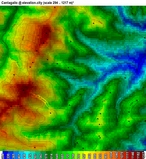
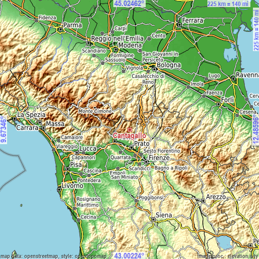
| \ | Map #1 | Topo.Map |
| Scale [m] | 294..1217 m | × |
| Scale [ft] | 965..3993 ft | × |
| Average | 706.5 m = 2318 ft | × |
| Width | 7.03 km = 4.4 mi | 224.9 km = 139.7 mi |
| Height | 7.03 km = 4.4 mi | 224.9 km = 139.7 mi |
| ↑Max Latitude | 44.053641° | 45.02462° |
| Latitude at center | 44.02205° | 44.02205° |
| ↓Min Latitude | 43.990442° | 43.00224° |
| ← Min Longitude | 11.035765° | 9.67346° |
| Longitude center | 11.07971° | 11.07971° |
| →Max Longitude | 11.123655° | 12.48596° |
Nearby cities:
Cities around Cantagallo sort by population:
• Montemurlo elevation 78 m
11.1 km,  197°
197°
• Fornacelle 68 m
11.5 km, 198°
• Vaiano 169 m
7 km,  149°
149°
• Montale 86 m
10.9 km,  207°
207°
• Barberino di Mugello 290 m
12.8 km,  101°
101°
• Vernio 303 m
6.3 km,  63°
63°
• Mercatale-San Quirico 254 m
6.3 km,  66°
66°
• Stazione 57 m
13 km, 203°
• Cavallina 273 m
12.9 km,  109°
109°
• Sambuca Pistoiese 511 m
11.2 km,  325°
325°
• Ponte della Venturina 413 m
14 km, 329°
• Molino del Pallone 488 m
12.8 km,  312°
312°
Multilingual:
 En español:
Cantagallo elevación 560 m.
 En France:
Cantagallo élévation 560 m.
 Auf Deutsch:
Cantagallo höhe über dem Meeresspiegel ist 560 m.

Sources and notes:
- [note 1] Map square and city borders are not equal. Map elevation data is calculated only from area inside that square.
- [src 1] Elevation data from geonames database provided with same terms of usage.
- [src 2] The elevation map of Cantagallo is generated using elevation data from NASA's 3 arcsec (90m) resolution SRTM data.
- [src 3] Base (background) map © OpenStreetMap contributors tiles are generated by Geofabrik and OpenTopoMap.
Copyright & License:
This Cantagallo Elevation Map is licensed under CC BY-SA. You may reuse any part from this page, if you give a proper credit by linking to this URL:
 More info on terms of use page.