Casacalenda elevation
Casacalenda (Molise, Provincia di Campobasso), Italy elevation is 621 meters and Casacalenda elevation in feet is 2037 ft above sea level [src 1]. Casacalenda is a seat of a third-order administrative division (feature code) with elevation that is 299 meters (981 ft) bigger than average city elevation in Italy.
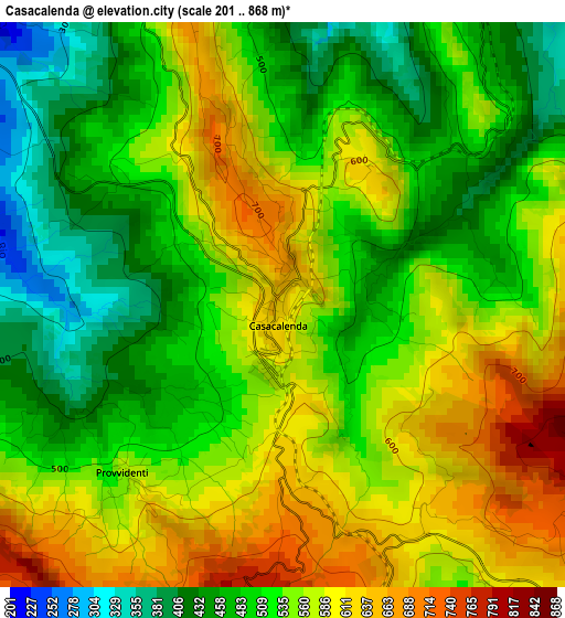
Below is the Elevation map of Casacalenda, which displays elevation range with different colors. Scale of the first map is from 201 to 868 m (659 to 2848 ft) with average elevation of 536 meters (=1759 ft) [note 1]
These maps also provides idea of topography and contour of this city, they are displayed at different zoom levels. More info about maps, scale and edge coordinates you can find below images.
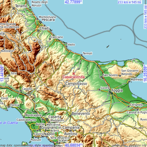
| \ | Map #1 | Topo.Map |
| Scale [m] | 201..868 m | × |
| Scale [ft] | 659..2848 ft | × |
| Average | 536 m = 1759 ft | × |
| Width | 7.29 km = 4.5 mi | 233.3 km = 145 mi |
| Height | 7.29 km = 4.5 mi | 233.3 km = 145 mi |
| ↑Max Latitude | 41.771023° | 42.77899° |
| Latitude at center | 41.73824° | 41.73824° |
| ↓Min Latitude | 41.70544° | 40.68034° |
| ← Min Longitude | 14.803395° | 13.44109° |
| Longitude center | 14.84734° | 14.84734° |
| →Max Longitude | 14.891285° | 16.25359° |
Nearby cities:
Cities around Casacalenda sort by population:
• Larino elevation 406 m
9.4 km,  38°
38°
• Bonefro 628 m
8.1 km,  117°
117°
• Guardialfiera 276 m
8.6 km,  328°
328°
• San Giuliano di Puglia 472 m
11.1 km, 120°
• Castellino del Biferno 456 m
10.4 km,  246°
246°
• Lupara 505 m
9.8 km,  285°
285°
• Morrone del Sannio 793 m
6.3 km,  241°
241°
• Ripabottoni 626 m
6.3 km,  210°
210°
• Montorio Nei Frentani 647 m
7.5 km,  72°
72°
• Montelongo 577 m
8.5 km,  90°
90°
• Castelbottaccio 622 m
11.8 km,  278°
278°
• Provvidenti 573 m
3 km,  221°
221°
Multilingual:
 En español:
Casacalenda elevación 621 m.
 En France:
Casacalenda élévation 621 m.
 Auf Deutsch:
Casacalenda höhe über dem Meeresspiegel ist 621 m.

Sources and notes:
- [note 1] Map square and city borders are not equal. Map elevation data is calculated only from area inside that square.
- [src 1] Elevation data from geonames database provided with same terms of usage.
- [src 2] The elevation map of Casacalenda is generated using elevation data from NASA's 3 arcsec (90m) resolution SRTM data.
- [src 3] Base (background) map © OpenStreetMap contributors tiles are generated by Geofabrik and OpenTopoMap.
Copyright & License:
This Casacalenda Elevation Map is licensed under CC BY-SA. You may reuse any part from this page, if you give a proper credit by linking to this URL:
 More info on terms of use page.