Casalbore elevation
Casalbore (Campania, Provincia di Avellino), Italy elevation is 596 meters and Casalbore elevation in feet is 1955 ft above sea level [src 1]. Casalbore is a seat of a third-order administrative division (feature code) with elevation that is 274 meters (899 ft) bigger than average city elevation in Italy.
Below is the Elevation map of Casalbore, which displays elevation range with different colors. Scale of the first map is from 235 to 933 m (771 to 3061 ft) with average elevation of 548.8 meters (=1801 ft) [note 1]
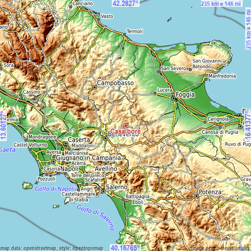
These maps also provides idea of topography and contour of this city, they are displayed at different zoom levels. More info about maps, scale and edge coordinates you can find below images.
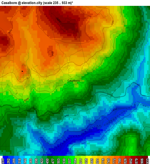
| \ | Map #1 | Topo.Map |
| Scale [m] | 235..933 m | × |
| Scale [ft] | 771..3061 ft | × |
| Average | 548.8 m = 1801 ft | × |
| Width | 7.35 km = 4.6 mi | 235.2 km = 146.1 mi |
| Height | 7.35 km = 4.6 mi | 235.2 km = 146.1 mi |
| ↑Max Latitude | 41.26677° | 42.2827° |
| Latitude at center | 41.23373° | 41.23373° |
| ↓Min Latitude | 41.200674° | 40.16765° |
| ← Min Longitude | 14.963575° | 13.60127° |
| Longitude center | 15.00752° | 15.00752° |
| →Max Longitude | 15.051465° | 16.41377° |
Nearby cities:
Cities around Casalbore sort by population:
• Ariano Irpino-Martiri elevation 617 m
11.6 km,  134°
134°
• Montecalvo Irpino 563 m
4.7 km,  151°
151°
• Paduli 365 m
12.5 km,  234°
234°
• Montefalcone di Val Fortore 840 m
10.1 km,  0°
0°
• Buonalbergo 545 m
2.8 km,  242°
242°
• Molinara 628 m
10.9 km,  310°
310°
• Pago Veiano 493 m
12 km,  274°
274°
• San Giorgio la Molara 643 m
8 km, 306°
• Foiano di Val Fortore 520 m
13.5 km,  348°
348°
• Castelfranco in Miscano 759 m
9.9 km,  41°
41°
• Ginestra degli Schiavoni 533 m
6 km,  30°
30°
• Sant'Arcangelo Trimonte 350 m
9.2 km,  218°
218°
Multilingual:
 En español:
Casalbore elevación 596 m.
 En France:
Casalbore élévation 596 m.
 Auf Deutsch:
Casalbore höhe über dem Meeresspiegel ist 596 m.

Sources and notes:
- [note 1] Map square and city borders are not equal. Map elevation data is calculated only from area inside that square.
- [src 1] Elevation data from geonames database provided with same terms of usage.
- [src 2] The elevation map of Casalbore is generated using elevation data from NASA's 3 arcsec (90m) resolution SRTM data.
- [src 3] Base (background) map © OpenStreetMap contributors tiles are generated by Geofabrik and OpenTopoMap.
Copyright & License:
This Casalbore Elevation Map is licensed under CC BY-SA. You may reuse any part from this page, if you give a proper credit by linking to this URL:
 More info on terms of use page.