Casaprota elevation
Casaprota (Latium, Provincia di Rieti), Italy elevation is 521 meters and Casaprota elevation in feet is 1709 ft above sea level [src 1]. Casaprota is a seat of a third-order administrative division (feature code) with elevation that is 199 meters (653 ft) bigger than average city elevation in Italy.
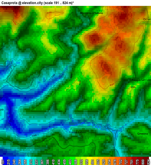
Below is the Elevation map of Casaprota, which displays elevation range with different colors. Scale of the first map is from 191 to 824 m (627 to 2703 ft) with average elevation of 443.1 meters (=1454 ft) [note 1]
These maps also provides idea of topography and contour of this city, they are displayed at different zoom levels. More info about maps, scale and edge coordinates you can find below images.
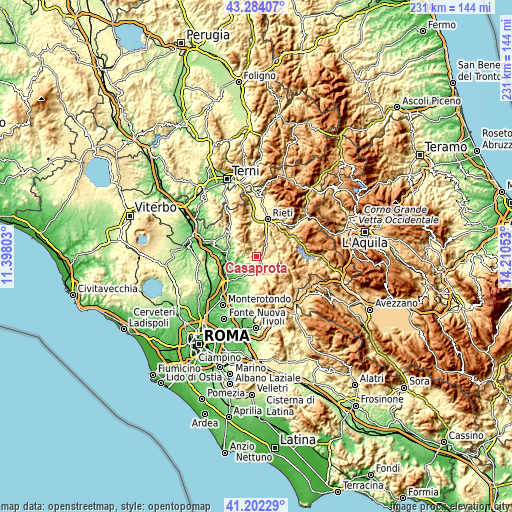
| \ | Map #1 | Topo.Map |
| Scale [m] | 191..824 m | × |
| Scale [ft] | 627..2703 ft | × |
| Average | 443.1 m = 1454 ft | × |
| Width | 7.23 km = 4.5 mi | 231.5 km = 143.8 mi |
| Height | 7.23 km = 4.5 mi | 231.5 km = 143.8 mi |
| ↑Max Latitude | 42.28429° | 43.28407° |
| Latitude at center | 42.25177° | 42.25177° |
| ↓Min Latitude | 42.219233° | 41.20229° |
| ← Min Longitude | 12.760335° | 11.39803° |
| Longitude center | 12.80428° | 12.80428° |
| →Max Longitude | 12.848225° | 14.21053° |
Nearby cities:
Cities around Casaprota sort by population:
• Poggio Moiano elevation 528 m
8.3 km,  129°
129°
• Poggio Nativo 419 m
3.8 km,  189°
189°
• Monteleone Sabino 480 m
4.9 km,  115°
115°
• Toffia 264 m
5.9 km,  223°
223°
• Castelnuovo di Farfa 355 m
5.5 km,  246°
246°
• Torricella in Sabina 618 m
5.7 km,  77°
77°
• Poggio San Lorenzo 495 m
3.2 km,  90°
90°
• Fara in Sabina 469 m
7.8 km,  231°
231°
• Salisano 443 m
4.7 km,  280°
280°
• Frasso Sabino 419 m
2.5 km,  175°
175°
• Mompeo 445 m
4.4 km,  264°
264°
• Montenero Sabino 431 m
3.4 km,  13°
13°
Multilingual:
 En español:
Casaprota elevación 521 m.
 En France:
Casaprota élévation 521 m.
 Auf Deutsch:
Casaprota höhe über dem Meeresspiegel ist 521 m.

Sources and notes:
- [note 1] Map square and city borders are not equal. Map elevation data is calculated only from area inside that square.
- [src 1] Elevation data from geonames database provided with same terms of usage.
- [src 2] The elevation map of Casaprota is generated using elevation data from NASA's 3 arcsec (90m) resolution SRTM data.
- [src 3] Base (background) map © OpenStreetMap contributors tiles are generated by Geofabrik and OpenTopoMap.
Copyright & License:
This Casaprota Elevation Map is licensed under CC BY-SA. You may reuse any part from this page, if you give a proper credit by linking to this URL:
 More info on terms of use page.