Cascina elevation
Cascina (Tuscany, Province of Pisa), Italy elevation is 10 meters and Cascina elevation in feet is 33 ft above sea level [src 1]. Cascina is a seat of a third-order administrative division (feature code) with elevation that is 312 meters (1024 ft) smaller than average city elevation in Italy.
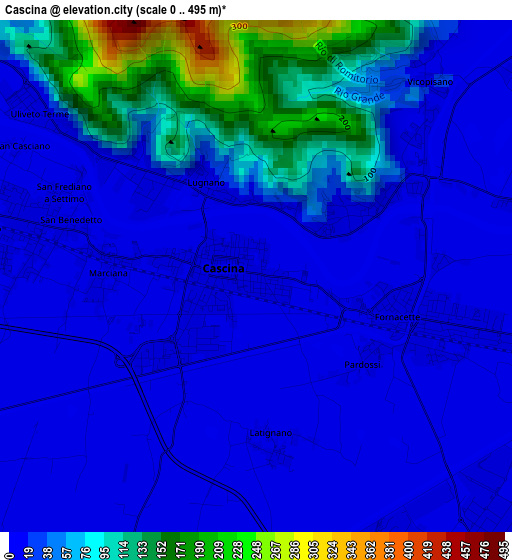
Below is the Elevation map of Cascina, which displays elevation range with different colors. Scale of the first map is from 0 to 495 m (0 to 1624 ft) with average elevation of 41.3 meters (=135 ft) [note 1]
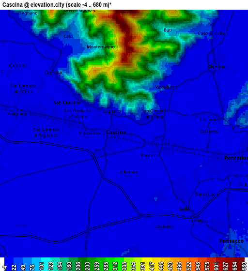
These maps also provides idea of topography and contour of this city, they are displayed at different zoom levels. More info about maps, scale and edge coordinates you can find below images.
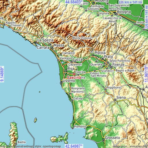
| \ | Map #1 | Map #2 | Topo.Map |
| Scale [m] | 0..495 m | -4..680 m | × |
| Scale [ft] | 0..1624 ft | -13..2231 ft | × |
| Average | 41.3 m = 135 ft | 53.5 m = 176 ft | × |
| Width | 7.07 km = 4.4 mi | 14.14 km = 8.8 mi | 226.2 km = 140.6 mi |
| Height | 7.07 km = 4.4 mi | 14.14 km = 8.8 mi | 226.2 km = 140.6 mi |
| ↑Max Latitude | 43.707346° | 43.739104° | 44.68403° |
| Latitude at center | 43.67557° | 43.67557° | 43.67557° |
| ↓Min Latitude | 43.643778° | 43.611968° | 42.64987° |
| ← Min Longitude | 10.510995° | 10.467049° | 9.14869° |
| Longitude center | 10.55494° | 10.55494° | 10.55494° |
| →Max Longitude | 10.598885° | 10.642831° | 11.96119° |
Nearby cities:
Cities around Cascina sort by population:
• Pontedera elevation 16 m
6.3 km,  104°
104°
• Fornacette 13 m
2.5 km, 103°
• Vicopisano 13 m
3 km,  49°
49°
• Bientina 14 m
6.4 km,  55°
55°
• Calci 47 m
6.3 km,  332°
332°
• Cascine-La Croce 36 m
7.6 km,  39°
39°
• Calcinaia 16 m
5 km,  79°
79°
• Buti 103 m
6.4 km,  21°
21°
• Uliveto Terme 10 m
3.8 km,  306°
306°
• Chiesino-Collodi 11 m
4.5 km, 84°
• Gabella 9 m
7.1 km,  319°
319°
• Campo 4 m
7.2 km,  300°
300°
Multilingual:
 En español:
Cascina elevación 10 m.
 En France:
Cascina élévation 10 m.


Sources and notes:
- [note 1] Map square and city borders are not equal. Map elevation data is calculated only from area inside that square.
- [src 1] Elevation data from geonames database provided with same terms of usage.
- [src 2] The elevation map of Cascina is generated using elevation data from NASA's 3 arcsec (90m) resolution SRTM data.
- [src 3] Base (background) map © OpenStreetMap contributors tiles are generated by Geofabrik and OpenTopoMap.
Copyright & License:
This Cascina Elevation Map is licensed under CC BY-SA. You may reuse any part from this page, if you give a proper credit by linking to this URL:
 More info on terms of use page.