Castel d'Aiano elevation
Castel d'Aiano (Emilia-Romagna, Bologna), Italy elevation is 830 meters and Castel d'Aiano elevation in feet is 2723 ft above sea level [src 1]. Castel d'Aiano is a seat of a third-order administrative division (feature code) with elevation that is 508 meters (1667 ft) bigger than average city elevation in Italy.
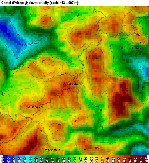
Below is the Elevation map of Castel d'Aiano, which displays elevation range with different colors. Scale of the first map is from 413 to 997 m (1355 to 3271 ft) with average elevation of 739.1 meters (=2425 ft) [note 1]
These maps also provides idea of topography and contour of this city, they are displayed at different zoom levels. More info about maps, scale and edge coordinates you can find below images.
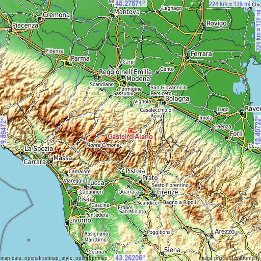
| \ | Map #1 | Topo.Map |
| Scale [m] | 413..997 m | × |
| Scale [ft] | 1355..3271 ft | × |
| Average | 739.1 m = 2425 ft | × |
| Width | 7 km = 4.3 mi | 223.9 km = 139.1 mi |
| Height | 7 km = 4.3 mi | 223.9 km = 139.1 mi |
| ↑Max Latitude | 44.308965° | 45.27571° |
| Latitude at center | 44.27751° | 44.27751° |
| ↓Min Latitude | 44.246038° | 43.26206° |
| ← Min Longitude | 10.957025° | 9.59472° |
| Longitude center | 11.00097° | 11.00097° |
| →Max Longitude | 11.044915° | 12.40722° |
Nearby cities:
Cities around Castel d'Aiano sort by population:
• Pavullo nel Frignano elevation 693 m
14.6 km,  295°
295°
• Vergato 199 m
8.7 km,  86°
86°
• Grizzana Morandi 554 m
12.3 km,  100°
100°
• Porretta Terme 342 m
12.9 km,  189°
189°
• Zocca 747 m
7.6 km,  355°
355°
• Gaggio Montano 604 m
10.5 km,  209°
209°
• Montese 793 m
4.5 km,  259°
259°
• Berzantina 389 m
13.4 km, 186°
• Savigno 264 m
14 km,  24°
24°
• Camugnano 704 m
13.7 km,  149°
149°
• Grizzana 557 m
12.5 km, 99°
• Castel di Casio 541 m
13 km,  167°
167°
Multilingual:
 En español:
Castel d'Aiano elevación 830 m.
 En France:
Castel d'Aiano élévation 830 m.
 Auf Deutsch:
Castel d'Aiano höhe über dem Meeresspiegel ist 830 m.

Sources and notes:
- [note 1] Map square and city borders are not equal. Map elevation data is calculated only from area inside that square.
- [src 1] Elevation data from geonames database provided with same terms of usage.
- [src 2] The elevation map of Castel d'Aiano is generated using elevation data from NASA's 3 arcsec (90m) resolution SRTM data.
- [src 3] Base (background) map © OpenStreetMap contributors tiles are generated by Geofabrik and OpenTopoMap.
Copyright & License:
This Castel d'Aiano Elevation Map is licensed under CC BY-SA. You may reuse any part from this page, if you give a proper credit by linking to this URL:
 More info on terms of use page.