Castelnovo di Sotto elevation
Castelnovo di Sotto (Emilia-Romagna, Provincia di Reggio Emilia), Italy elevation is 28 meters and Castelnovo di Sotto elevation in feet is 92 ft above sea level [src 1]. Castelnovo di Sotto is a seat of a third-order administrative division (feature code) with elevation that is 294 meters (965 ft) smaller than average city elevation in Italy.
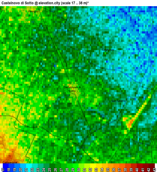
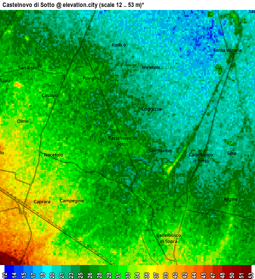
Below is the Elevation map of Castelnovo di Sotto, which displays elevation range with different colors. Scale of the first map is from 17 to 38 m (56 to 125 ft) with average elevation of 25.8 meters (=85 ft) [note 1]
These maps also provides idea of topography and contour of this city, they are displayed at different zoom levels. More info about maps, scale and edge coordinates you can find below images.
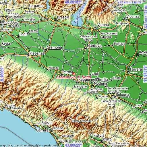
| \ | Map #1 | Map #2 | Topo.Map |
| Scale [m] | 17..38 m | 12..53 m | × |
| Scale [ft] | 56..125 ft | 39..174 ft | × |
| Average | 25.8 m = 85 ft | 27 m = 89 ft | × |
| Width | 6.93 km = 4.3 mi | 13.87 km = 8.6 mi | 221.8 km = 137.8 mi |
| Height | 6.93 km = 4.3 mi | 13.87 km = 8.6 mi | 221.8 km = 137.8 mi |
| ↑Max Latitude | 44.843697° | 44.874847° | 45.80152° |
| Latitude at center | 44.81253° | 44.81253° | 44.81253° |
| ↓Min Latitude | 44.781346° | 44.750145° | 43.80629° |
| ← Min Longitude | 10.522995° | 10.479049° | 9.16069° |
| Longitude center | 10.56694° | 10.56694° | 10.56694° |
| →Max Longitude | 10.610885° | 10.654831° | 11.97319° |
Nearby cities:
Cities around Castelnovo di Sotto sort by population:
• Cadelbosco di Sopra elevation 34 m
5.8 km,  154°
154°
• Poviglio 31 m
4 km,  326°
326°
• Praticello 36 m
7.5 km,  263°
263°
• Campegine 36 m
4.7 km,  220°
220°
• Lentigione-Sorbolo a Mane 29 m
8.9 km,  312°
312°
• Cadè-Gaida 50 m
9.2 km,  206°
206°
• Santa Vittoria 21 m
7 km,  48°
48°
• Roncocesi 41 m
8.3 km,  173°
173°
• Cadelbosco di Sotto 25 m
4 km,  107°
107°
• Caprara 37 m
6 km,  226°
226°
• Argine 29 m
6.8 km,  128°
128°
• Praticello di Gattatico 39 m
7.3 km, 263°
Multilingual:
 En español:
Castelnovo di Sotto elevación 28 m.
 En France:
Castelnovo di Sotto élévation 28 m.
 Auf Deutsch:
Castelnovo di Sotto höhe über dem Meeresspiegel ist 28 m.
 На русском:
Castelnovo di Sotto высота над уровнем моря 28 м
Sources and notes:
- [note 1] Map square and city borders are not equal. Map elevation data is calculated only from area inside that square.
- [src 1] Elevation data from geonames database provided with same terms of usage.
- [src 2] The elevation map of Castelnovo di Sotto is generated using elevation data from NASA's 3 arcsec (90m) resolution SRTM data.
- [src 3] Base (background) map © OpenStreetMap contributors tiles are generated by Geofabrik and OpenTopoMap.
Copyright & License:
This Castelnovo di Sotto Elevation Map is licensed under CC BY-SA. You may reuse any part from this page, if you give a proper credit by linking to this URL:
 More info on terms of use page.