Castelpoto elevation
Castelpoto (Campania, Provincia di Benevento), Italy elevation is 277 meters and Castelpoto elevation in feet is 909 ft above sea level [src 1]. Castelpoto is a seat of a third-order administrative division (feature code) with elevation that is 45 meters (148 ft) smaller than average city elevation in Italy.
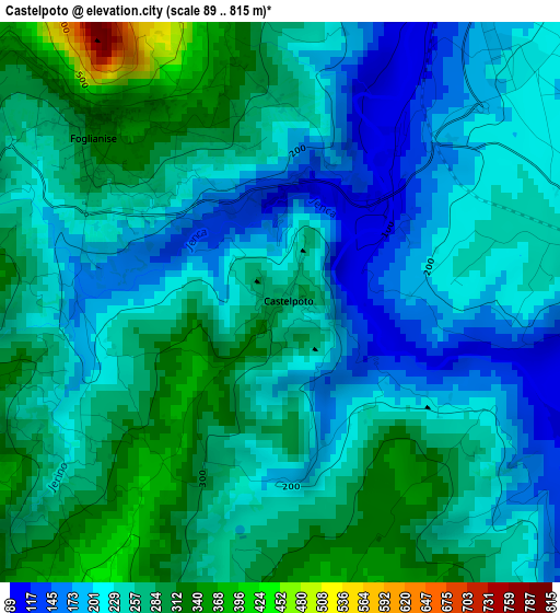
Below is the Elevation map of Castelpoto, which displays elevation range with different colors. Scale of the first map is from 89 to 815 m (292 to 2674 ft) with average elevation of 245.3 meters (=805 ft) [note 1]
These maps also provides idea of topography and contour of this city, they are displayed at different zoom levels. More info about maps, scale and edge coordinates you can find below images.
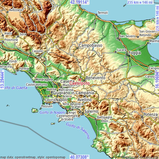
| \ | Map #1 | Topo.Map |
| Scale [m] | 89..815 m | × |
| Scale [ft] | 292..2674 ft | × |
| Average | 245.3 m = 805 ft | × |
| Width | 7.36 km = 4.6 mi | 235.5 km = 146.3 mi |
| Height | 7.36 km = 4.6 mi | 235.5 km = 146.3 mi |
| ↑Max Latitude | 41.173747° | 42.19114° |
| Latitude at center | 41.14066° | 41.14066° |
| ↓Min Latitude | 41.107557° | 40.07308° |
| ← Min Longitude | 14.656745° | 13.29444° |
| Longitude center | 14.70069° | 14.70069° |
| →Max Longitude | 14.744635° | 16.10694° |
Nearby cities:
Cities around Castelpoto sort by population:
• Benevento elevation 154 m
6.6 km,  99°
99°
• Foglianise 325 m
3.4 km,  312°
312°
• Vitulano 431 m
5.8 km, 310°
• Ponte 123 m
8.3 km,  358°
358°
• Beltiglio-San Giovanni 378 m
9.7 km,  153°
153°
• San Leucio del Sannio-Cavuoti 362 m
8.8 km, 147°
• Cautano 306 m
4.8 km,  282°
282°
• Torrecuso 449 m
5.3 km,  342°
342°
• Apollosa 451 m
5.5 km,  183°
183°
• Campoli del Monte Taburno 438 m
4.7 km,  256°
256°
• Paupisi 333 m
6.9 km,  334°
334°
• Tocco Caudio 532 m
5.8 km,  253°
253°
Multilingual:
 En español:
Castelpoto elevación 277 m.
 En France:
Castelpoto élévation 277 m.
 Auf Deutsch:
Castelpoto höhe über dem Meeresspiegel ist 277 m.

Sources and notes:
- [note 1] Map square and city borders are not equal. Map elevation data is calculated only from area inside that square.
- [src 1] Elevation data from geonames database provided with same terms of usage.
- [src 2] The elevation map of Castelpoto is generated using elevation data from NASA's 3 arcsec (90m) resolution SRTM data.
- [src 3] Base (background) map © OpenStreetMap contributors tiles are generated by Geofabrik and OpenTopoMap.
Copyright & License:
This Castelpoto Elevation Map is licensed under CC BY-SA. You may reuse any part from this page, if you give a proper credit by linking to this URL:
 More info on terms of use page.