Castronno elevation
Castronno (Lombardy, Provincia di Varese), Italy elevation is 357 meters and Castronno elevation in feet is 1171 ft above sea level [src 1]. Castronno is a seat of a third-order administrative division (feature code) with elevation that is 35 meters (115 ft) bigger than average city elevation in Italy.
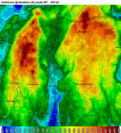
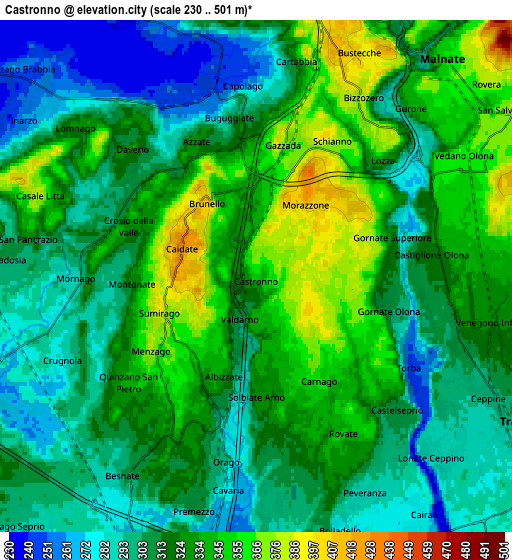
Below is the Elevation map of Castronno, which displays elevation range with different colors. Scale of the first map is from 281 to 439 m (922 to 1440 ft) with average elevation of 358.5 meters (=1176 ft) [note 1]
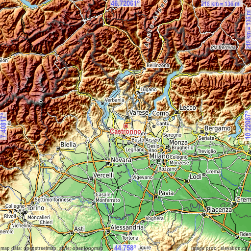
These maps also provides idea of topography and contour of this city, they are displayed at different zoom levels. More info about maps, scale and edge coordinates you can find below images.
| \ | Map #1 | Map #2 | Topo.Map |
| Scale [m] | 281..439 m | 230..501 m | × |
| Scale [ft] | 922..1440 ft | 755..1644 ft | × |
| Average | 358.5 m = 1176 ft | 319.3 m = 1048 ft | × |
| Width | 6.82 km = 4.2 mi | 13.64 km = 8.5 mi | 218.2 km = 135.6 mi |
| Height | 6.82 km = 4.2 mi | 13.64 km = 8.5 mi | 218.2 km = 135.6 mi |
| ↑Max Latitude | 45.778587° | 45.809228° | 46.72061° |
| Latitude at center | 45.74793° | 45.74793° | 45.74793° |
| ↓Min Latitude | 45.717256° | 45.686565° | 44.758° |
| ← Min Longitude | 8.770475° | 8.726529° | 7.40817° |
| Longitude center | 8.81442° | 8.81442° | 8.81442° |
| →Max Longitude | 8.858365° | 8.902311° | 10.22067° |
Nearby cities:
Cities around Castronno sort by population:
• Sumirago elevation 376 m
2.7 km,  242°
242°
• Carnago 354 m
3.3 km,  151°
151°
• Albizzate 341 m
2.5 km,  200°
200°
• Caronno Varesino 389 m
1.9 km,  135°
135°
• Azzate 327 m
3.7 km,  334°
334°
• Morazzone 397 m
2.1 km,  30°
30°
• Buguggiate 316 m
3.8 km,  355°
355°
• Solbiate Arno 323 m
3.2 km,  180°
180°
• Gornate Olona 307 m
3.6 km,  101°
101°
• Monte 346 m
3.7 km,  170°
170°
• Brunello 405 m
2.4 km,  321°
321°
• Crosio della Valle 325 m
3.7 km,  291°
291°
Multilingual:
 En español:
Castronno elevación 357 m.
 En France:
Castronno élévation 357 m.
 Auf Deutsch:
Castronno höhe über dem Meeresspiegel ist 357 m.

Sources and notes:
- [note 1] Map square and city borders are not equal. Map elevation data is calculated only from area inside that square.
- [src 1] Elevation data from geonames database provided with same terms of usage.
- [src 2] The elevation map of Castronno is generated using elevation data from NASA's 3 arcsec (90m) resolution SRTM data.
- [src 3] Base (background) map © OpenStreetMap contributors tiles are generated by Geofabrik and OpenTopoMap.
Copyright & License:
This Castronno Elevation Map is licensed under CC BY-SA. You may reuse any part from this page, if you give a proper credit by linking to this URL:
 More info on terms of use page.