Cercepiccola elevation
Cercepiccola (Molise, Provincia di Campobasso), Italy elevation is 683 meters and Cercepiccola elevation in feet is 2241 ft above sea level [src 1]. Cercepiccola is a seat of a third-order administrative division (feature code) with elevation that is 361 meters (1184 ft) bigger than average city elevation in Italy.
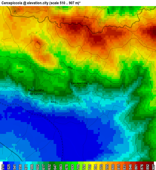
Below is the Elevation map of Cercepiccola, which displays elevation range with different colors. Scale of the first map is from 510 to 907 m (1673 to 2976 ft) with average elevation of 661.4 meters (=2170 ft) [note 1]
These maps also provides idea of topography and contour of this city, they are displayed at different zoom levels. More info about maps, scale and edge coordinates you can find below images.
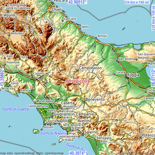
| \ | Map #1 | Topo.Map |
| Scale [m] | 510..907 m | × |
| Scale [ft] | 1673..2976 ft | × |
| Average | 661.4 m = 2170 ft | × |
| Width | 7.32 km = 4.5 mi | 234.4 km = 145.6 mi |
| Height | 7.32 km = 4.5 mi | 234.3 km = 145.6 mi |
| ↑Max Latitude | 41.492745° | 42.50512° |
| Latitude at center | 41.45982° | 41.45982° |
| ↓Min Latitude | 41.426878° | 40.3974° |
| ← Min Longitude | 14.620925° | 13.25862° |
| Longitude center | 14.66487° | 14.66487° |
| →Max Longitude | 14.708815° | 16.07112° |
Nearby cities:
Cities around Cercepiccola sort by population:
• Campobasso elevation 675 m
11.1 km,  1°
1°
• Vinchiaturo 625 m
7.1 km,  301°
301°
• Mirabello Sannitico 557 m
6.3 km,  6°
6°
• Mimosa-Poggio Verde-Nuova Comunità 718 m
8.8 km, 2°
• Cercemaggiore 952 m
4.9 km,  88°
88°
• Sepino 703 m
6.9 km,  213°
213°
• Ferrazzano 835 m
7.9 km, 4°
• San Giuliano del Sannio 656 m
1.9 km,  262°
262°
• Santa Croce del Sannio 697 m
9.8 km,  144°
144°
• Guardiaregia 715 m
10.5 km,  254°
254°
• Sassinoro 542 m
9.5 km,  180°
180°
• Gildone 622 m
8.3 km,  48°
48°
Multilingual:
 En español:
Cercepiccola elevación 683 m.
 En France:
Cercepiccola élévation 683 m.
 Auf Deutsch:
Cercepiccola höhe über dem Meeresspiegel ist 683 m.

Sources and notes:
- [note 1] Map square and city borders are not equal. Map elevation data is calculated only from area inside that square.
- [src 1] Elevation data from geonames database provided with same terms of usage.
- [src 2] The elevation map of Cercepiccola is generated using elevation data from NASA's 3 arcsec (90m) resolution SRTM data.
- [src 3] Base (background) map © OpenStreetMap contributors tiles are generated by Geofabrik and OpenTopoMap.
Copyright & License:
This Cercepiccola Elevation Map is licensed under CC BY-SA. You may reuse any part from this page, if you give a proper credit by linking to this URL:
 More info on terms of use page.