Cersosimo elevation
Cersosimo (Basilicate, Provincia di Potenza), Italy elevation is 586 meters and Cersosimo elevation in feet is 1923 ft above sea level [src 1]. Cersosimo is a seat of a third-order administrative division (feature code) with elevation that is 264 meters (866 ft) bigger than average city elevation in Italy.
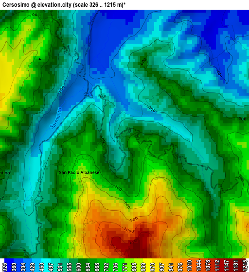
Below is the Elevation map of Cersosimo, which displays elevation range with different colors. Scale of the first map is from 326 to 1215 m (1070 to 3986 ft) with average elevation of 622.3 meters (=2042 ft) [note 1]
These maps also provides idea of topography and contour of this city, they are displayed at different zoom levels. More info about maps, scale and edge coordinates you can find below images.
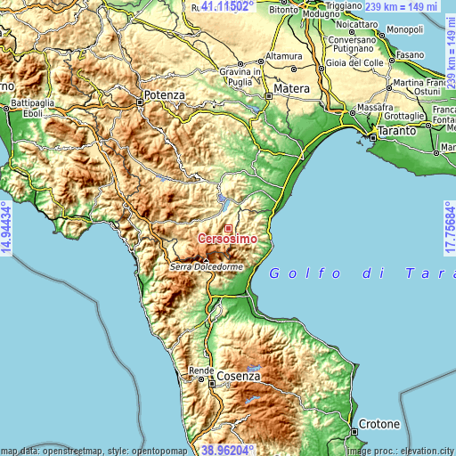
| \ | Map #1 | Topo.Map |
| Scale [m] | 326..1215 m | × |
| Scale [ft] | 1070..3986 ft | × |
| Average | 622.3 m = 2042 ft | × |
| Width | 7.48 km = 4.6 mi | 239.4 km = 148.8 mi |
| Height | 7.48 km = 4.6 mi | 239.4 km = 148.8 mi |
| ↑Max Latitude | 40.080663° | 41.11502° |
| Latitude at center | 40.04703° | 40.04703° |
| ↓Min Latitude | 40.013381° | 38.96204° |
| ← Min Longitude | 16.306645° | 14.94434° |
| Longitude center | 16.35059° | 16.35059° |
| →Max Longitude | 16.394535° | 17.75684° |
Nearby cities:
Cities around Cersosimo sort by population:
• Senise elevation 350 m
12.2 km,  334°
334°
• Francavilla in Sinni 424 m
13 km,  287°
287°
• Oriolo 445 m
8.2 km,  85°
85°
• San Giorgio Lucano 366 m
7.9 km,  24°
24°
• Terranova di Pollino 863 m
9 km,  211°
211°
• Noepoli 648 m
4.8 km,  336°
336°
• Canna 403 m
14.1 km,  67°
67°
• San Costantino Albanese 648 m
4.1 km,  253°
253°
• Alessandria del Carretto 997 m
10.1 km,  165°
165°
• Nocara 851 m
12.6 km,  62°
62°
• San Paolo Albanese 812 m
1.8 km,  226°
226°
• Castroregio 807 m
12.5 km,  119°
119°
Multilingual:
 En español:
Cersosimo elevación 586 m.
 En France:
Cersosimo élévation 586 m.
 Auf Deutsch:
Cersosimo höhe über dem Meeresspiegel ist 586 m.

Sources and notes:
- [note 1] Map square and city borders are not equal. Map elevation data is calculated only from area inside that square.
- [src 1] Elevation data from geonames database provided with same terms of usage.
- [src 2] The elevation map of Cersosimo is generated using elevation data from NASA's 3 arcsec (90m) resolution SRTM data.
- [src 3] Base (background) map © OpenStreetMap contributors tiles are generated by Geofabrik and OpenTopoMap.
Copyright & License:
This Cersosimo Elevation Map is licensed under CC BY-SA. You may reuse any part from this page, if you give a proper credit by linking to this URL:
 More info on terms of use page.