Chianni elevation
Chianni (Tuscany, Province of Pisa), Italy elevation is 332 meters and Chianni elevation in feet is 1089 ft above sea level [src 1]. Chianni is a seat of a third-order administrative division (feature code) with elevation that is 10 meters (33 ft) bigger than average city elevation in Italy.
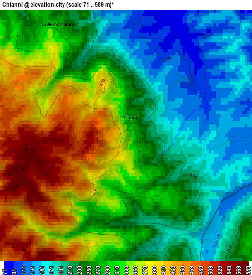
Below is the Elevation map of Chianni, which displays elevation range with different colors. Scale of the first map is from 71 to 589 m (233 to 1932 ft) with average elevation of 283 meters (=928 ft) [note 1]
These maps also provides idea of topography and contour of this city, they are displayed at different zoom levels. More info about maps, scale and edge coordinates you can find below images.
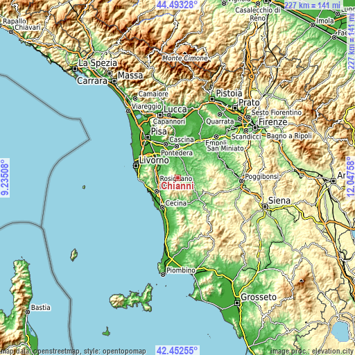
| \ | Map #1 | Topo.Map |
| Scale [m] | 71..589 m | × |
| Scale [ft] | 233..1932 ft | × |
| Average | 283 m = 928 ft | × |
| Width | 7.09 km = 4.4 mi | 226.9 km = 141 mi |
| Height | 7.09 km = 4.4 mi | 226.9 km = 141 mi |
| ↑Max Latitude | 43.513408° | 44.49328° |
| Latitude at center | 43.48153° | 43.48153° |
| ↓Min Latitude | 43.449635° | 42.45255° |
| ← Min Longitude | 10.597385° | 9.23508° |
| Longitude center | 10.64133° | 10.64133° |
| →Max Longitude | 10.685275° | 12.04758° |
Nearby cities:
Cities around Chianni sort by population:
• Peccioli elevation 90 m
9.7 km,  38°
38°
• Casciana Terme 118 m
5.4 km,  339°
339°
• San Pietro Belvedere 130 m
10 km,  11°
11°
• Selvatelle 49 m
9.9 km,  23°
23°
• Terricciola 182 m
5.7 km,  32°
32°
• Lari 128 m
10.2 km, 337°
• Castellina Marittima 366 m
9.3 km,  214°
214°
• Lajatico 211 m
7.1 km,  96°
96°
• Crespina 77 m
11.9 km,  328°
328°
• Orciano Pisano 118 m
10.6 km,  277°
277°
• Santa Luce 191 m
6.4 km,  259°
259°
• Lorenzana 117 m
10.5 km,  304°
304°
Multilingual:
 En español:
Chianni elevación 332 m.
 En France:
Chianni élévation 332 m.


Sources and notes:
- [note 1] Map square and city borders are not equal. Map elevation data is calculated only from area inside that square.
- [src 1] Elevation data from geonames database provided with same terms of usage.
- [src 2] The elevation map of Chianni is generated using elevation data from NASA's 3 arcsec (90m) resolution SRTM data.
- [src 3] Base (background) map © OpenStreetMap contributors tiles are generated by Geofabrik and OpenTopoMap.
Copyright & License:
This Chianni Elevation Map is licensed under CC BY-SA. You may reuse any part from this page, if you give a proper credit by linking to this URL:
 More info on terms of use page.