Chiari elevation
Chiari (Lombardy, Provincia di Brescia), Italy elevation is 150 meters and Chiari elevation in feet is 492 ft above sea level [src 1]. Chiari is a seat of a third-order administrative division (feature code) with elevation that is 172 meters (564 ft) smaller than average city elevation in Italy.
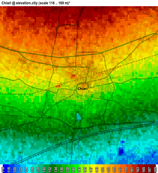
Below is the Elevation map of Chiari, which displays elevation range with different colors. Scale of the first map is from 116 to 169 m (381 to 554 ft) with average elevation of 144 meters (=472 ft) [note 1]
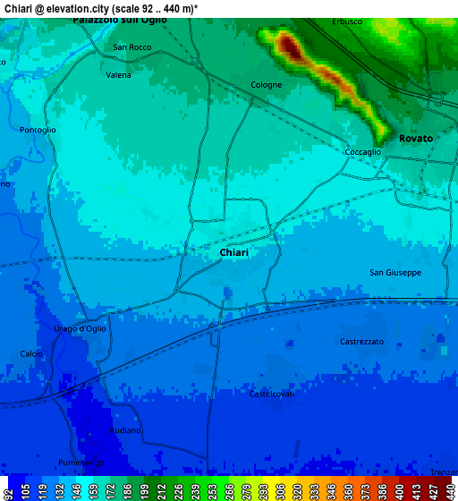
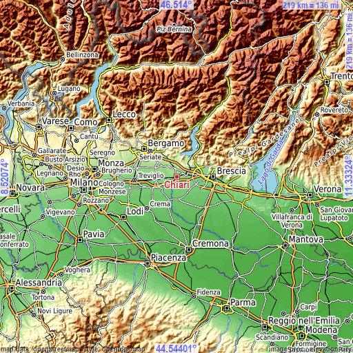
These maps also provides idea of topography and contour of this city, they are displayed at different zoom levels. More info about maps, scale and edge coordinates you can find below images.
| \ | Map #1 | Map #2 | Topo.Map |
| Scale [m] | 116..169 m | 92..440 m | × |
| Scale [ft] | 381..554 ft | 302..1444 ft | × |
| Average | 144 m = 472 ft | 145.8 m = 478 ft | × |
| Width | 6.85 km = 4.3 mi | 13.69 km = 8.5 mi | 219 km = 136.1 mi |
| Height | 6.85 km = 4.3 mi | 13.69 km = 8.5 mi | 219 km = 136.1 mi |
| ↑Max Latitude | 45.568403° | 45.599158° | 46.514° |
| Latitude at center | 45.53763° | 45.53763° | 45.53763° |
| ↓Min Latitude | 45.50684° | 45.476034° | 44.54401° |
| ← Min Longitude | 9.883045° | 9.839099° | 8.52074° |
| Longitude center | 9.92699° | 9.92699° | 9.92699° |
| →Max Longitude | 9.970935° | 10.014881° | 11.33324° |
Nearby cities:
Cities around Chiari sort by population:
• Palazzolo sull'Oglio elevation 178 m
7.3 km,  334°
334°
• Rovato 169 m
6.5 km,  63°
63°
• Coccaglio 159 m
4.6 km,  50°
50°
• Cologne 174 m
4.7 km,  14°
14°
• Castrezzato 125 m
5.1 km,  124°
124°
• Castelcovati 121 m
4.2 km,  159°
159°
• Pontoglio 154 m
6.7 km,  301°
301°
• Rudiano 115 m
6.2 km,  210°
210°
• Calcio 124 m
6.9 km,  241°
241°
• Urago d'Oglio 132 m
5.1 km, 241°
• Villa Pedergnano 209 m
7.4 km,  44°
44°
• Duomo 145 m
7.4 km,  94°
94°
Multilingual:
 En español:
Chiari elevación 150 m.
 En France:
Chiari élévation 150 m.


Sources and notes:
- [note 1] Map square and city borders are not equal. Map elevation data is calculated only from area inside that square.
- [src 1] Elevation data from geonames database provided with same terms of usage.
- [src 2] The elevation map of Chiari is generated using elevation data from NASA's 3 arcsec (90m) resolution SRTM data.
- [src 3] Base (background) map © OpenStreetMap contributors tiles are generated by Geofabrik and OpenTopoMap.
Copyright & License:
This Chiari Elevation Map is licensed under CC BY-SA. You may reuse any part from this page, if you give a proper credit by linking to this URL:
 More info on terms of use page.