Cimego elevation
Cimego (Trentino-Alto Adige, Provincia autonoma di Trento), Italy elevation is 533 meters and Cimego elevation in feet is 1749 ft above sea level [src 1]. Cimego is a seat of a third-order administrative division (feature code) with elevation that is 211 meters (692 ft) bigger than average city elevation in Italy.
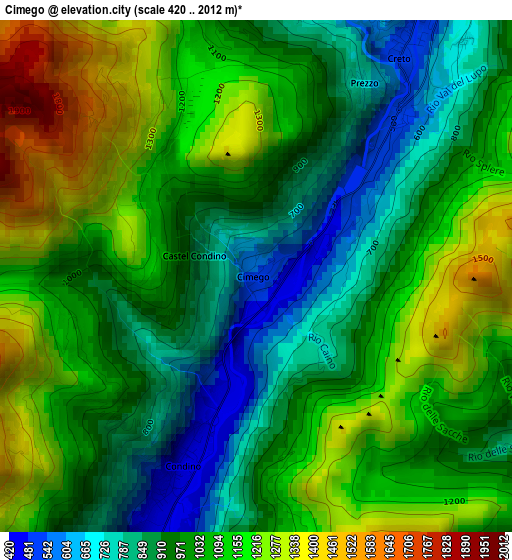
Below is the Elevation map of Cimego, which displays elevation range with different colors. Scale of the first map is from 420 to 2012 m (1378 to 6601 ft) with average elevation of 1036 meters (=3399 ft) [note 1]
These maps also provides idea of topography and contour of this city, they are displayed at different zoom levels. More info about maps, scale and edge coordinates you can find below images.
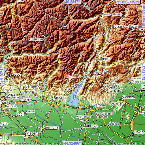
| \ | Map #1 | Topo.Map |
| Scale [m] | 420..2012 m | × |
| Scale [ft] | 1378..6601 ft | × |
| Average | 1036 m = 3399 ft | × |
| Width | 6.8 km = 4.2 mi | 217.6 km = 135.2 mi |
| Height | 6.8 km = 4.2 mi | 217.6 km = 135.2 mi |
| ↑Max Latitude | 45.942467° | 46.8817° |
| Latitude at center | 45.9119° | 45.9119° |
| ↓Min Latitude | 45.881316° | 44.92486° |
| ← Min Longitude | 10.569425° | 9.20712° |
| Longitude center | 10.61337° | 10.61337° |
| →Max Longitude | 10.657315° | 12.01962° |
Nearby cities:
Cities around Cimego sort by population:
• Storo elevation 395 m
7.4 km,  200°
200°
• Condino 423 m
3.7 km, 204°
• Pieve di Bono 539 m
4 km,  31°
31°
• Roncone 806 m
8.9 km, 28°
• Creto 523 m
3.9 km, 32°
• Daone 780 m
4 km,  8°
8°
• Praso 795 m
4.6 km,  22°
22°
• Bersone 621 m
3.9 km, 22°
• Castel Condino 852 m
0.9 km,  288°
288°
• Prezzo 631 m
3 km, 30°
• Lardaro 724 m
7.4 km, 30°
• Brione 907 m
2.6 km,  224°
224°
Multilingual:
 En español:
Cimego elevación 533 m.
 En France:
Cimego élévation 533 m.


Sources and notes:
- [note 1] Map square and city borders are not equal. Map elevation data is calculated only from area inside that square.
- [src 1] Elevation data from geonames database provided with same terms of usage.
- [src 2] The elevation map of Cimego is generated using elevation data from NASA's 3 arcsec (90m) resolution SRTM data.
- [src 3] Base (background) map © OpenStreetMap contributors tiles are generated by Geofabrik and OpenTopoMap.
Copyright & License:
This Cimego Elevation Map is licensed under CC BY-SA. You may reuse any part from this page, if you give a proper credit by linking to this URL:
 More info on terms of use page.