Cintano elevation
Cintano (Piedmont, Torino), Italy elevation is 649 meters and Cintano elevation in feet is 2129 ft above sea level [src 1]. Cintano is a seat of a third-order administrative division (feature code) with elevation that is 327 meters (1073 ft) bigger than average city elevation in Italy.
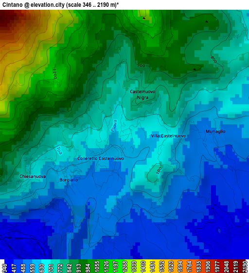
Below is the Elevation map of Cintano, which displays elevation range with different colors. Scale of the first map is from 346 to 2190 m (1135 to 7185 ft) with average elevation of 745.8 meters (=2447 ft) [note 1]
These maps also provides idea of topography and contour of this city, they are displayed at different zoom levels. More info about maps, scale and edge coordinates you can find below images.
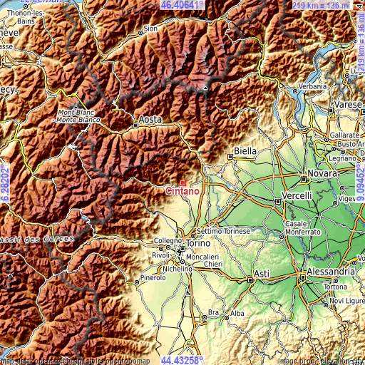
| \ | Map #1 | Topo.Map |
| Scale [m] | 346..2190 m | × |
| Scale [ft] | 1135..7185 ft | × |
| Average | 745.8 m = 2447 ft | × |
| Width | 6.86 km = 4.3 mi | 219.5 km = 136.4 mi |
| Height | 6.86 km = 4.3 mi | 219.5 km = 136.4 mi |
| ↑Max Latitude | 45.458953° | 46.40641° |
| Latitude at center | 45.42812° | 45.42812° |
| ↓Min Latitude | 45.397271° | 44.43258° |
| ← Min Longitude | 7.644325° | 6.28202° |
| Longitude center | 7.68827° | 7.68827° |
| →Max Longitude | 7.732215° | 9.09452° |
Nearby cities:
Cities around Cintano sort by population:
• Cuorgnè elevation 399 m
4.9 km,  217°
217°
• Castellamonte 348 m
5.3 km,  162°
162°
• Vistrorio 478 m
6.4 km,  76°
76°
• Issiglio 492 m
5.5 km,  68°
68°
• Vidracco 481 m
5.4 km,  87°
87°
• Colleretto Castelnuovo 589 m
0.9 km,  225°
225°
• Borgiallo 554 m
1.9 km, 230°
• Strambinello 382 m
6.4 km,  95°
95°
• Baldissero Canavese 391 m
4.8 km,  114°
114°
• Frassinetto 1081 m
6.3 km,  280°
280°
• Castelnuovo Nigra 830 m
1.2 km,  23°
23°
• Chiesanuova 661 m
2.8 km,  245°
245°
Multilingual:
 En español:
Cintano elevación 649 m.
 En France:
Cintano élévation 649 m.


Sources and notes:
- [note 1] Map square and city borders are not equal. Map elevation data is calculated only from area inside that square.
- [src 1] Elevation data from geonames database provided with same terms of usage.
- [src 2] The elevation map of Cintano is generated using elevation data from NASA's 3 arcsec (90m) resolution SRTM data.
- [src 3] Base (background) map © OpenStreetMap contributors tiles are generated by Geofabrik and OpenTopoMap.
Copyright & License:
This Cintano Elevation Map is licensed under CC BY-SA. You may reuse any part from this page, if you give a proper credit by linking to this URL:
 More info on terms of use page.