Cirigliano elevation
Cirigliano (Basilicate, Provincia di Matera), Italy elevation is 649 meters and Cirigliano elevation in feet is 2129 ft above sea level [src 1]. Cirigliano is a seat of a third-order administrative division (feature code) with elevation that is 327 meters (1073 ft) bigger than average city elevation in Italy.
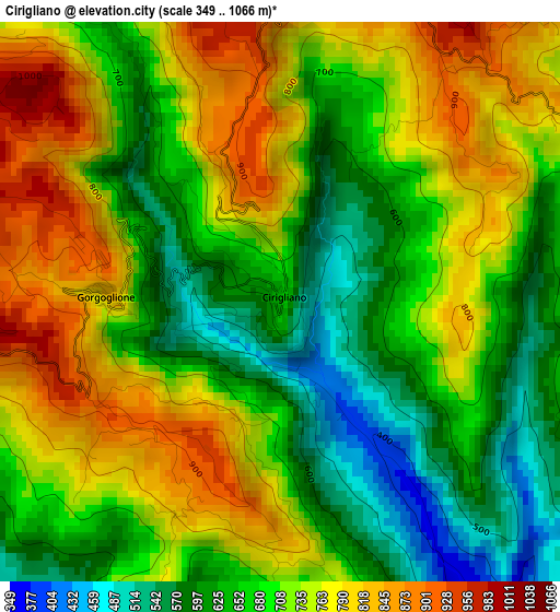
Below is the Elevation map of Cirigliano, which displays elevation range with different colors. Scale of the first map is from 349 to 1066 m (1145 to 3497 ft) with average elevation of 703.9 meters (=2309 ft) [note 1]
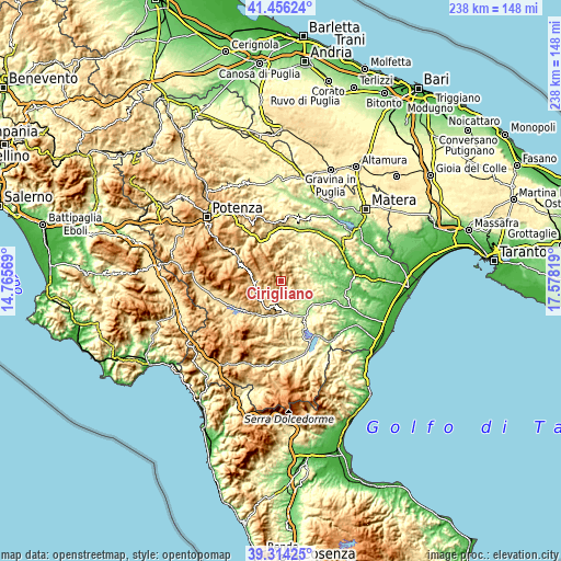
These maps also provides idea of topography and contour of this city, they are displayed at different zoom levels. More info about maps, scale and edge coordinates you can find below images.
| \ | Map #1 | Topo.Map |
| Scale [m] | 349..1066 m | × |
| Scale [ft] | 1145..3497 ft | × |
| Average | 703.9 m = 2309 ft | × |
| Width | 7.44 km = 4.6 mi | 238.2 km = 148 mi |
| Height | 7.44 km = 4.6 mi | 238.2 km = 148 mi |
| ↑Max Latitude | 40.427221° | 41.45624° |
| Latitude at center | 40.39376° | 40.39376° |
| ↓Min Latitude | 40.360283° | 39.31425° |
| ← Min Longitude | 16.127995° | 14.76569° |
| Longitude center | 16.17194° | 16.17194° |
| →Max Longitude | 16.215885° | 17.57819° |
Nearby cities:
Cities around Cirigliano sort by population:
• Stigliano elevation 872 m
5 km,  78°
78°
• Corleto Perticara 785 m
11.3 km,  263°
263°
• Accettura 785 m
10.9 km,  353°
353°
• San Mauro Forte 495 m
12 km,  34°
34°
• Gorgoglione 821 m
2.3 km,  274°
274°
• Pietrapertosa 949 m
16.6 km,  326°
326°
• Gallicchio 764 m
11.7 km,  195°
195°
• Aliano 543 m
10.2 km,  151°
151°
• Armento 648 m
13.2 km,  222°
222°
• Guardia Perticara 725 m
7.2 km,  240°
240°
• Missanello 623 m
12.3 km,  182°
182°
• Oliveto Lucano 543 m
15.8 km,  4°
4°
Multilingual:
 En español:
Cirigliano elevación 649 m.
 En France:
Cirigliano élévation 649 m.
 Auf Deutsch:
Cirigliano höhe über dem Meeresspiegel ist 649 m.

Sources and notes:
- [note 1] Map square and city borders are not equal. Map elevation data is calculated only from area inside that square.
- [src 1] Elevation data from geonames database provided with same terms of usage.
- [src 2] The elevation map of Cirigliano is generated using elevation data from NASA's 3 arcsec (90m) resolution SRTM data.
- [src 3] Base (background) map © OpenStreetMap contributors tiles are generated by Geofabrik and OpenTopoMap.
Copyright & License:
This Cirigliano Elevation Map is licensed under CC BY-SA. You may reuse any part from this page, if you give a proper credit by linking to this URL:
 More info on terms of use page.