Cittareale elevation
Cittareale (Latium, Provincia di Rieti), Italy elevation is 941 meters and Cittareale elevation in feet is 3087 ft above sea level [src 1]. Cittareale is a seat of a third-order administrative division (feature code) with elevation that is 619 meters (2031 ft) bigger than average city elevation in Italy.
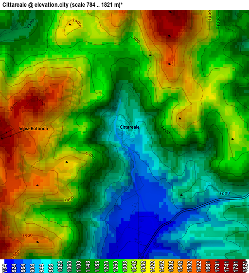
Below is the Elevation map of Cittareale, which displays elevation range with different colors. Scale of the first map is from 784 to 1821 m (2572 to 5974 ft) with average elevation of 1236 meters (=4055 ft) [note 1]
These maps also provides idea of topography and contour of this city, they are displayed at different zoom levels. More info about maps, scale and edge coordinates you can find below images.
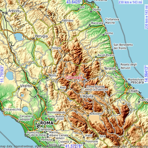
| \ | Map #1 | Topo.Map |
| Scale [m] | 784..1821 m | × |
| Scale [ft] | 2572..5974 ft | × |
| Average | 1236 m = 4055 ft | × |
| Width | 7.19 km = 4.5 mi | 230.1 km = 143 mi |
| Height | 7.19 km = 4.5 mi | 230.1 km = 143 mi |
| ↑Max Latitude | 42.648571° | 43.6425° |
| Latitude at center | 42.61624° | 42.61624° |
| ↓Min Latitude | 42.583892° | 41.57278° |
| ← Min Longitude | 13.113935° | 11.75163° |
| Longitude center | 13.15788° | 13.15788° |
| →Max Longitude | 13.201825° | 14.56413° |
Nearby cities:
Cities around Cittareale sort by population:
• Norcia elevation 604 m
20.1 km,  345°
345°
• Cascia 618 m
16.1 km,  314°
314°
• Leonessa 953 m
17 km,  251°
251°
• Amatrice 960 m
11.3 km,  84°
84°
• Montereale 937 m
12.6 km,  145°
145°
• Borbona 780 m
12.1 km,  190°
190°
• Capitignano 906 m
15.9 km,  132°
132°
• Cagnano Amiterno 859 m
18.6 km,  162°
162°
• Monteleone di Spoleto 944 m
17.3 km,  282°
282°
• Campotosto 1407 m
18.3 km,  110°
110°
• Posta 726 m
11.2 km,  206°
206°
• Accumoli 858 m
11.4 km,  40°
40°
Multilingual:
 En español:
Cittareale elevación 941 m.
 En France:
Cittareale élévation 941 m.
 Auf Deutsch:
Cittareale höhe über dem Meeresspiegel ist 941 m.

Sources and notes:
- [note 1] Map square and city borders are not equal. Map elevation data is calculated only from area inside that square.
- [src 1] Elevation data from geonames database provided with same terms of usage.
- [src 2] The elevation map of Cittareale is generated using elevation data from NASA's 3 arcsec (90m) resolution SRTM data.
- [src 3] Base (background) map © OpenStreetMap contributors tiles are generated by Geofabrik and OpenTopoMap.
Copyright & License:
This Cittareale Elevation Map is licensed under CC BY-SA. You may reuse any part from this page, if you give a proper credit by linking to this URL:
 More info on terms of use page.