Collazzone elevation
Collazzone (Umbria, Provincia di Perugia), Italy elevation is 461 meters and Collazzone elevation in feet is 1512 ft above sea level [src 1]. Collazzone is a seat of a third-order administrative division (feature code) with elevation that is 139 meters (456 ft) bigger than average city elevation in Italy.
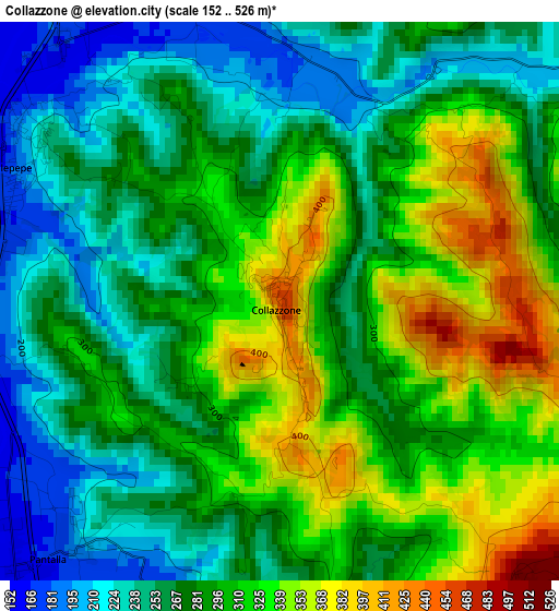
Below is the Elevation map of Collazzone, which displays elevation range with different colors. Scale of the first map is from 152 to 526 m (499 to 1726 ft) with average elevation of 289.1 meters (=948 ft) [note 1]
These maps also provides idea of topography and contour of this city, they are displayed at different zoom levels. More info about maps, scale and edge coordinates you can find below images.
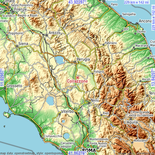
| \ | Map #1 | Topo.Map |
| Scale [m] | 152..526 m | × |
| Scale [ft] | 499..1726 ft | × |
| Average | 289.1 m = 948 ft | × |
| Width | 7.16 km = 4.4 mi | 229.1 km = 142.4 mi |
| Height | 7.16 km = 4.4 mi | 229.1 km = 142.4 mi |
| ↑Max Latitude | 42.933653° | 43.92297° |
| Latitude at center | 42.90147° | 42.90147° |
| ↓Min Latitude | 42.869271° | 41.86276° |
| ← Min Longitude | 12.391875° | 11.02957° |
| Longitude center | 12.43582° | 12.43582° |
| →Max Longitude | 12.479765° | 13.84207° |
Nearby cities:
Cities around Collazzone sort by population:
• Marsciano elevation 187 m
7.3 km,  287°
287°
• Deruta 168 m
9.4 km,  350°
350°
• Bastardo 285 m
10.6 km,  108°
108°
• Ponterio-Pian di Porto 149 m
10.6 km,  191°
191°
• Pantalla 166 m
4.4 km,  223°
223°
• Collepepe 189 m
3.7 km,  295°
295°
• San Terenziano 523 m
4.9 km,  141°
141°
• San Niccolò di Celle 174 m
13.5 km,  341°
341°
• Fratta Todina 210 m
7.7 km,  229°
229°
• Bettona 348 m
12.9 km,  18°
18°
• Monte Castello di Vibio 414 m
9.6 km, 225°
• Gualdo Cattaneo 452 m
9.9 km,  83°
83°
Multilingual:
 En español:
Collazzone elevación 461 m.
 En France:
Collazzone élévation 461 m.
 Auf Deutsch:
Collazzone höhe über dem Meeresspiegel ist 461 m.

Sources and notes:
- [note 1] Map square and city borders are not equal. Map elevation data is calculated only from area inside that square.
- [src 1] Elevation data from geonames database provided with same terms of usage.
- [src 2] The elevation map of Collazzone is generated using elevation data from NASA's 3 arcsec (90m) resolution SRTM data.
- [src 3] Base (background) map © OpenStreetMap contributors tiles are generated by Geofabrik and OpenTopoMap.
Copyright & License:
This Collazzone Elevation Map is licensed under CC BY-SA. You may reuse any part from this page, if you give a proper credit by linking to this URL:
 More info on terms of use page.