Cornalba elevation
Cornalba (Lombardy, Provincia di Bergamo), Italy elevation is 841 meters and Cornalba elevation in feet is 2759 ft above sea level [src 1]. Cornalba is a seat of a third-order administrative division (feature code) with elevation that is 519 meters (1703 ft) bigger than average city elevation in Italy.
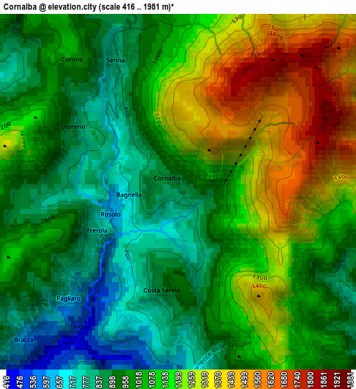
Below is the Elevation map of Cornalba, which displays elevation range with different colors. Scale of the first map is from 416 to 1981 m (1365 to 6499 ft) with average elevation of 1065.9 meters (=3497 ft) [note 1]
These maps also provides idea of topography and contour of this city, they are displayed at different zoom levels. More info about maps, scale and edge coordinates you can find below images.
| \ | Map #1 | Topo.Map |
| Scale [m] | 416..1981 m | × |
| Scale [ft] | 1365..6499 ft | × |
| Average | 1065.9 m = 3497 ft | × |
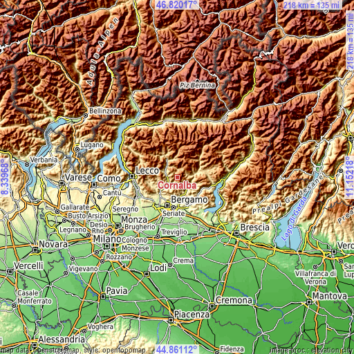
| Width | 6.81 km = 4.2 mi | 217.8 km = 135.3 mi |
| Height | 6.81 km = 4.2 mi | 217.8 km = 135.3 mi |
| ↑Max Latitude | 45.879872° | 46.82017° |
| Latitude at center | 45.84927° | 45.84927° |
| ↓Min Latitude | 45.818652° | 44.86112° |
| ← Min Longitude | 9.701985° | 8.33968° |
| Longitude center | 9.74593° | 9.74593° |
| →Max Longitude | 9.789875° | 11.15218° |
Nearby cities:
Cities around Cornalba sort by population:
• San Pellegrino Terme elevation 364 m
6.3 km,  254°
254°
• Selvino 965 m
7.1 km,  175°
175°
• Gorno 683 m
7.5 km,  78°
78°
• Serina 814 m
2.6 km,  334°
334°
• Oneta 742 m
6.2 km,  66°
66°
• Dossena 992 m
5.1 km,  312°
312°
• Oltre Il Colle 1073 m
4.8 km,  21°
21°
• Costa di Serina 888 m
1.9 km,  190°
190°
• Villa d'Oneta 715 m
6.2 km, 67°
• Aviatico 980 m
6.1 km,  161°
161°
• Bracca 589 m
4.2 km,  224°
224°
• Algua 447 m
3.2 km, 215°
Multilingual:
 En español:
Cornalba elevación 841 m.
 En France:
Cornalba élévation 841 m.
 Auf Deutsch:
Cornalba höhe über dem Meeresspiegel ist 841 m.

Sources and notes:
- [note 1] Map square and city borders are not equal. Map elevation data is calculated only from area inside that square.
- [src 1] Elevation data from geonames database provided with same terms of usage.
- [src 2] The elevation map of Cornalba is generated using elevation data from NASA's 3 arcsec (90m) resolution SRTM data.
- [src 3] Base (background) map © OpenStreetMap contributors tiles are generated by Geofabrik and OpenTopoMap.
Copyright & License:
This Cornalba Elevation Map is licensed under CC BY-SA. You may reuse any part from this page, if you give a proper credit by linking to this URL:
 More info on terms of use page.