Covo elevation
Covo (Lombardy, Provincia di Bergamo), Italy elevation is 115 meters and Covo elevation in feet is 377 ft above sea level [src 1]. Covo is a seat of a third-order administrative division (feature code) with elevation that is 207 meters (679 ft) smaller than average city elevation in Italy.
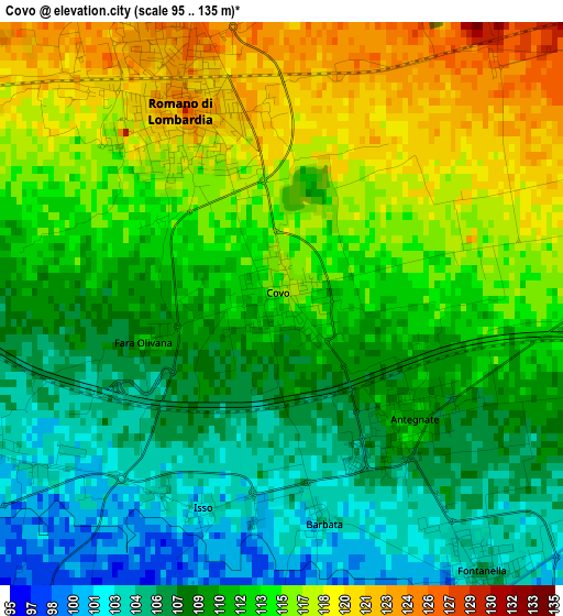
Below is the Elevation map of Covo, which displays elevation range with different colors. Scale of the first map is from 95 to 135 m (312 to 443 ft) with average elevation of 111.7 meters (=366 ft) [note 1]
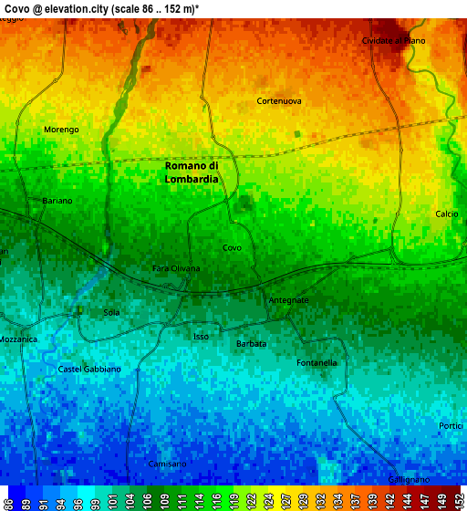
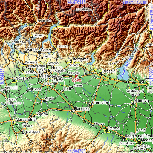
These maps also provides idea of topography and contour of this city, they are displayed at different zoom levels. More info about maps, scale and edge coordinates you can find below images.
| \ | Map #1 | Map #2 | Topo.Map |
| Scale [m] | 95..135 m | 86..152 m | × |
| Scale [ft] | 312..443 ft | 282..499 ft | × |
| Average | 111.7 m = 366 ft | 112.6 m = 369 ft | × |
| Width | 6.85 km = 4.3 mi | 13.7 km = 8.5 mi | 219.2 km = 136.2 mi |
| Height | 6.85 km = 4.3 mi | 13.7 km = 8.5 mi | 219.2 km = 136.2 mi |
| ↑Max Latitude | 45.529854° | 45.560631° | 46.47611° |
| Latitude at center | 45.49906° | 45.49906° | 45.49906° |
| ↓Min Latitude | 45.468249° | 45.437422° | 44.50476° |
| ← Min Longitude | 9.726735° | 9.682789° | 8.36443° |
| Longitude center | 9.77068° | 9.77068° | 9.77068° |
| →Max Longitude | 9.814625° | 9.858571° | 11.17693° |
Nearby cities:
Cities around Covo sort by population:
• Romano di Lombardia elevation 125 m
2.7 km,  332°
332°
• Calcio 124 m
6.2 km,  80°
80°
• Bariano 117 m
5.4 km,  286°
286°
• Fontanella 105 m
4.2 km,  143°
143°
• Antegnate 110 m
2.1 km,  130°
130°
• Morengo 125 m
6.2 km,  305°
305°
• Cortenuova 134 m
4.6 km,  16°
16°
• Camisano 94 m
6.3 km,  198°
198°
• Barbata 103 m
2.7 km,  168°
168°
• Fara Olivana 112 m
1.7 km,  255°
255°
• Castel Gabbiano 99 m
5.4 km,  230°
230°
• Isso 102 m
2.6 km, 200°
Multilingual:
 En español:
Covo elevación 115 m.
 En France:
Covo élévation 115 m.


Sources and notes:
- [note 1] Map square and city borders are not equal. Map elevation data is calculated only from area inside that square.
- [src 1] Elevation data from geonames database provided with same terms of usage.
- [src 2] The elevation map of Covo is generated using elevation data from NASA's 3 arcsec (90m) resolution SRTM data.
- [src 3] Base (background) map © OpenStreetMap contributors tiles are generated by Geofabrik and OpenTopoMap.
Copyright & License:
This Covo Elevation Map is licensed under CC BY-SA. You may reuse any part from this page, if you give a proper credit by linking to this URL:
 More info on terms of use page.